Saint-Savin, Isère
Saint-Savin | |
|---|---|
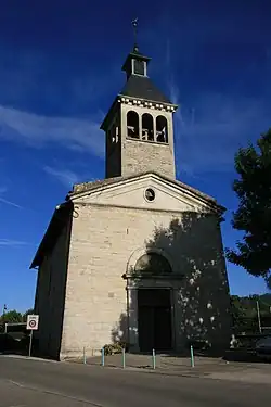 The church of Saint-Savin | |
 Coat of arms | |
Location of Saint-Savin | |
 Saint-Savin  Saint-Savin | |
| Coordinates: 45°37′46″N 5°18′24″E / 45.6294°N 5.3067°E | |
| Country | France |
| Region | Auvergne-Rhône-Alpes |
| Department | Isère |
| Arrondissement | La Tour-du-Pin |
| Canton | Bourgoin-Jallieu |
| Intercommunality | CA Porte de l'Isère |
| Government | |
| • Mayor (2020–2026) | Fabien Durand[1] |
Area 1 | 24.55 km2 (9.48 sq mi) |
| Population (2022)[2] | 4,297 |
| • Density | 180/km2 (450/sq mi) |
| Time zone | UTC+01:00 (CET) |
| • Summer (DST) | UTC+02:00 (CEST) |
| INSEE/Postal code | 38455 /38300 |
| Elevation | 216–403 m (709–1,322 ft) (avg. 250 m or 820 ft) |
| 1 French Land Register data, which excludes lakes, ponds, glaciers > 1 km2 (0.386 sq mi or 247 acres) and river estuaries. | |
Saint-Savin (French pronunciation: [sɛ̃ savɛ̃]; Arpitan: Sant-Savin) is a commune in the Isère department in southeastern France.[3]
Population
|
| ||||||||||||||||||||||||||||||||||||||||||||||||||||||
| Source: EHESS[4] and INSEE (1968-2017)[5] | |||||||||||||||||||||||||||||||||||||||||||||||||||||||
See also
References
- ^ "Répertoire national des élus: les maires" (in French). data.gouv.fr, Plateforme ouverte des données publiques françaises. 13 September 2022.
- ^ "Populations de référence 2022" (in French). The National Institute of Statistics and Economic Studies. 19 December 2024.
- ^ INSEE commune file
- ^ Des villages de Cassini aux communes d'aujourd'hui: Commune data sheet Saint-Savin, EHESS (in French).
- ^ Population en historique depuis 1968, INSEE
Wikimedia Commons has media related to Saint-Savin, Isère.