Choranche
Choranche | |
|---|---|
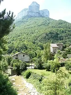 A general view of Choranche | |
Location of Choranche | |
 Choranche  Choranche | |
| Coordinates: 45°04′04″N 5°23′30″E / 45.0678°N 5.3917°E | |
| Country | France |
| Region | Auvergne-Rhône-Alpes |
| Department | Isère |
| Arrondissement | Grenoble |
| Canton | Le Sud Grésivaudan |
| Government | |
| • Mayor (2020–2026) | Geneviève Moreau-Glenat[1] |
Area 1 | 10.63 km2 (4.10 sq mi) |
| Population (2022)[2] | 140 |
| • Density | 13/km2 (34/sq mi) |
| Time zone | UTC+01:00 (CET) |
| • Summer (DST) | UTC+02:00 (CEST) |
| INSEE/Postal code | 38108 /38680 |
| Elevation | 200–1,200 m (660–3,940 ft) |
| 1 French Land Register data, which excludes lakes, ponds, glaciers > 1 km2 (0.386 sq mi or 247 acres) and river estuaries. | |
Choranche (French pronunciation: [ʃɔʁɑ̃ʃ]; Occitan: Chaurança) is a commune in the Isère department in southeastern France.
Famous is Choranche Cave. The grottoes were discovered end the 19th Century and hide a unique sight of fine stalactites.[3]
Population
| Year | Pop. | ±% p.a. |
|---|---|---|
| 1968 | 149 | — |
| 1975 | 115 | −3.63% |
| 1982 | 130 | +1.77% |
| 1990 | 132 | +0.19% |
| 1999 | 130 | −0.17% |
| 2007 | 134 | +0.38% |
| 2012 | 132 | −0.30% |
| 2017 | 121 | −1.73% |
| Source: INSEE[4] | ||
See also
References
- ^ "Répertoire national des élus: les maires" (in French). data.gouv.fr, Plateforme ouverte des données publiques françaises. 4 May 2022.
- ^ "Populations de référence 2022" (in French). The National Institute of Statistics and Economic Studies. 19 December 2024.
- ^ "About Choranche". Archived from the original on 25 June 2015. Retrieved 13 September 2015.
- ^ Population en historique depuis 1968, INSEE
Wikimedia Commons has media related to Choranche.