Saint-Élix-Theux
Saint-Élix-Theux | |
|---|---|
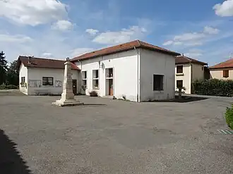 The town hall in Saint-Élix-Theux | |
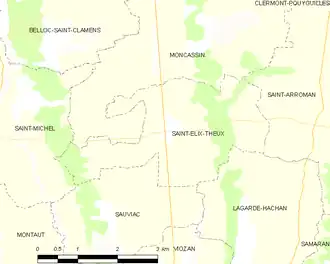
Location of Saint-Élix-Theux | |
 Saint-Élix-Theux  Saint-Élix-Theux | |
| Coordinates: 43°25′47″N 0°28′14″E / 43.4297°N 0.4706°E | |
| Country | France |
| Region | Occitania |
| Department | Gers |
| Arrondissement | Mirande |
| Canton | Mirande-Astarac |
| Government | |
| • Mayor (2020–2026) | Jean-Michel Laffitte[1] |
Area 1 | 8.37 km2 (3.23 sq mi) |
| Population (2022)[2] | 87 |
| • Density | 10/km2 (27/sq mi) |
| Time zone | UTC+01:00 (CET) |
| • Summer (DST) | UTC+02:00 (CEST) |
| INSEE/Postal code | 32375 /32300 |
| Elevation | 193–302 m (633–991 ft) (avg. 209 m or 686 ft) |
| 1 French Land Register data, which excludes lakes, ponds, glaciers > 1 km2 (0.386 sq mi or 247 acres) and river estuaries. | |
Saint-Élix-Theux is a commune in the Gers department in southwestern France.
Geography
The Petite Baïse flows north through the eastern part of the commune.
Population
| Year | Pop. | ±% |
|---|---|---|
| 1962 | 170 | — |
| 1968 | 167 | −1.8% |
| 1975 | 152 | −9.0% |
| 1982 | 145 | −4.6% |
| 1990 | 131 | −9.7% |
| 1999 | 110 | −16.0% |
| 2008 | 111 | +0.9% |
See also
References
- ^ "Répertoire national des élus: les maires". data.gouv.fr, Plateforme ouverte des données publiques françaises (in French). 2 December 2020.
- ^ "Populations de référence 2022" (in French). The National Institute of Statistics and Economic Studies. 19 December 2024.
Wikimedia Commons has media related to Saint-Élix-Theux.