Espas, Gers
Espas | |
|---|---|
 Town hall | |
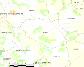
Location of Espas | |
 Espas  Espas | |
| Coordinates: 43°46′55″N 0°04′17″E / 43.7819°N 0.0714°E | |
| Country | France |
| Region | Occitania |
| Department | Gers |
| Arrondissement | Condom |
| Canton | Grand-Bas-Armagnac |
| Government | |
| • Mayor (2020–2026) | Pierre Cazères[1] |
Area 1 | 15.13 km2 (5.84 sq mi) |
| Population (2022)[2] | 132 |
| • Density | 8.7/km2 (23/sq mi) |
| Time zone | UTC+01:00 (CET) |
| • Summer (DST) | UTC+02:00 (CEST) |
| INSEE/Postal code | 32125 /32370 |
| Elevation | 119–221 m (390–725 ft) (avg. 217 m or 712 ft) |
| 1 French Land Register data, which excludes lakes, ponds, glaciers > 1 km2 (0.386 sq mi or 247 acres) and river estuaries. | |
Espas is a commune in the Gers department in southwestern France.
Geography
Population
| Year | Pop. | ±% |
|---|---|---|
| 1962 | 231 | — |
| 1968 | 188 | −18.6% |
| 1975 | 183 | −2.7% |
| 1982 | 151 | −17.5% |
| 1990 | 132 | −12.6% |
| 1999 | 124 | −6.1% |
| 2008 | 115 | −7.3% |
See also
References
- ^ "Répertoire national des élus: les maires". data.gouv.fr, Plateforme ouverte des données publiques françaises (in French). 2 December 2020.
- ^ "Populations de référence 2022" (in French). The National Institute of Statistics and Economic Studies. 19 December 2024.
Wikimedia Commons has media related to Espas.