Cadeilhan
Cadeilhan | |
|---|---|
Location of Cadeilhan | |
 Cadeilhan  Cadeilhan | |
| Coordinates: 43°49′47″N 0°46′20″E / 43.8297°N 0.7722°E | |
| Country | France |
| Region | Occitania |
| Department | Gers |
| Arrondissement | Condom |
| Canton | Fleurance-Lomagne |
| Intercommunality | Lomagne Gersoise |
| Government | |
| • Mayor (2020–2026) | Édouard Schmidt[1] |
Area 1 | 8.43 km2 (3.25 sq mi) |
| Population (2022)[2] | 145 |
| • Density | 17/km2 (45/sq mi) |
| Time zone | UTC+01:00 (CET) |
| • Summer (DST) | UTC+02:00 (CEST) |
| INSEE/Postal code | 32068 /32380 |
| Elevation | 122–194 m (400–636 ft) (avg. 180 m or 590 ft) |
| 1 French Land Register data, which excludes lakes, ponds, glaciers > 1 km2 (0.386 sq mi or 247 acres) and river estuaries. | |
Cadeilhan (French pronunciation: [kadɛjɑ̃]; Occitan: Cadelhan) is a commune in the Gers department in southwestern France.
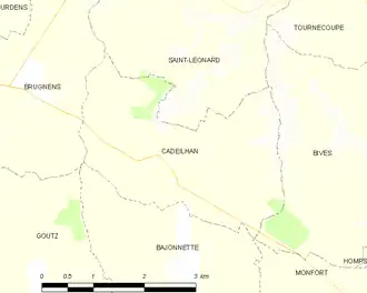
Geography
The river Auroue forms most of the commune's western border.
Population
| Year | Pop. | ±% |
|---|---|---|
| 1962 | 132 | — |
| 1968 | 111 | −15.9% |
| 1975 | 121 | +9.0% |
| 1982 | 117 | −3.3% |
| 1990 | 100 | −14.5% |
| 1999 | 100 | +0.0% |
| 2007 | 133 | +33.0% |
| 2012 | 124 | −6.8% |
| 2014 | 123 | −0.8% |
See also
References
- ^ "Répertoire national des élus: les maires". data.gouv.fr, Plateforme ouverte des données publiques françaises (in French). 2 December 2020.
- ^ "Populations de référence 2022" (in French). The National Institute of Statistics and Economic Studies. 19 December 2024.
Wikimedia Commons has media related to Cadeilhan.