Bajonnette
Bajonnette | |
|---|---|
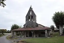 The church in Bajonnette | |
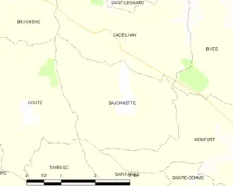
Location of Bajonnette | |
 Bajonnette  Bajonnette | |
| Coordinates: 43°48′35″N 0°46′12″E / 43.8097°N 0.77°E | |
| Country | France |
| Region | Occitania |
| Department | Gers |
| Arrondissement | Condom |
| Canton | Gimone-Arrats |
| Government | |
| • Mayor (2020–2026) | Alexandre Laffont[1] |
Area 1 | 7.48 km2 (2.89 sq mi) |
| Population (2022)[2] | 108 |
| • Density | 14/km2 (37/sq mi) |
| Time zone | UTC+01:00 (CET) |
| • Summer (DST) | UTC+02:00 (CEST) |
| INSEE/Postal code | 32026 /32120 |
| Elevation | 134–212 m (440–696 ft) (avg. 178 m or 584 ft) |
| 1 French Land Register data, which excludes lakes, ponds, glaciers > 1 km2 (0.386 sq mi or 247 acres) and river estuaries. | |
Bajonnette (French pronunciation: [baʒɔnɛt]; Occitan: Bajoneta) is a commune in the Gers department in southwestern France.
Geography
Population
| Year | Pop. | ±% |
|---|---|---|
| 1962 | 152 | — |
| 1968 | 159 | +4.6% |
| 1975 | 146 | −8.2% |
| 1982 | 135 | −7.5% |
| 1990 | 103 | −23.7% |
| 1999 | 92 | −10.7% |
| 2008 | 103 | +12.0% |
Sites of interest
- Saint-Orens church
See also
References
- ^ "Répertoire national des élus: les maires". data.gouv.fr, Plateforme ouverte des données publiques françaises (in French). 9 August 2021.
- ^ "Populations de référence 2022" (in French). The National Institute of Statistics and Economic Studies. 19 December 2024.
Wikimedia Commons has media related to Bajonnette.