Castéron
Castéron | |
|---|---|
.svg.png) Coat of arms | |
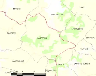
Location of Castéron | |
 Castéron  Castéron | |
| Coordinates: 43°53′34″N 0°51′42″E / 43.8928°N 0.8617°E | |
| Country | France |
| Region | Occitania |
| Department | Gers |
| Arrondissement | Condom |
| Canton | Fleurance-Lomagne |
| Government | |
| • Mayor (2020–2026) | Christiane Pieters[1] |
Area 1 | 11.08 km2 (4.28 sq mi) |
| Population (2022)[2] | 52 |
| • Density | 4.7/km2 (12/sq mi) |
| Time zone | UTC+01:00 (CET) |
| • Summer (DST) | UTC+02:00 (CEST) |
| INSEE/Postal code | 32084 /32380 |
| Elevation | 165–267 m (541–876 ft) (avg. 266 m or 873 ft) |
| 1 French Land Register data, which excludes lakes, ponds, glaciers > 1 km2 (0.386 sq mi or 247 acres) and river estuaries. | |
Castéron (French pronunciation: [kasteʁɔ̃]; Occitan: Lo Casteron) is a commune in the Gers department in southwestern France.
Geography
Population
| Year | Pop. | ±% |
|---|---|---|
| 1962 | 141 | — |
| 1968 | 128 | −9.2% |
| 1975 | 116 | −9.4% |
| 1982 | 97 | −16.4% |
| 1990 | 67 | −30.9% |
| 1999 | 58 | −13.4% |
| 2008 | 67 | +15.5% |
See also
References
- ^ "Répertoire national des élus: les maires". data.gouv.fr, Plateforme ouverte des données publiques françaises (in French). 2 December 2020.
- ^ "Populations de référence 2022" (in French). The National Institute of Statistics and Economic Studies. 19 December 2024.
Wikimedia Commons has media related to Castéron.