Raulhac
Raulhac | |
|---|---|
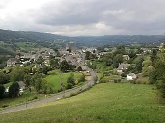 A general view of Raulhac | |
 Coat of arms | |
Location of Raulhac | |
 Raulhac  Raulhac | |
| Coordinates: 44°54′01″N 2°39′25″E / 44.9003°N 2.6569°E | |
| Country | France |
| Region | Auvergne-Rhône-Alpes |
| Department | Cantal |
| Arrondissement | Aurillac |
| Canton | Vic-sur-Cère |
| Intercommunality | Cère et Goul en Carladès |
| Government | |
| • Mayor (2020–2026) | Philippe Matiere[1] |
Area 1 | 16.98 km2 (6.56 sq mi) |
| Population (2022)[2] | 273 |
| • Density | 16/km2 (42/sq mi) |
| Time zone | UTC+01:00 (CET) |
| • Summer (DST) | UTC+02:00 (CEST) |
| INSEE/Postal code | 15159 /15800 |
| Elevation | 539–995 m (1,768–3,264 ft) (avg. 740 m or 2,430 ft) |
| 1 French Land Register data, which excludes lakes, ponds, glaciers > 1 km2 (0.386 sq mi or 247 acres) and river estuaries. | |
Raulhac is a commune in the Cantal department in south-central France.
Population
| Year | Pop. | ±% p.a. |
|---|---|---|
| 1968 | 448 | — |
| 1975 | 386 | −2.11% |
| 1982 | 350 | −1.39% |
| 1990 | 364 | +0.49% |
| 1999 | 332 | −1.02% |
| 2007 | 349 | +0.63% |
| 2012 | 302 | −2.85% |
| 2017 | 272 | −2.07% |
| Source: INSEE[3] | ||
See also
References
- ^ "Répertoire national des élus: les maires". data.gouv.fr, Plateforme ouverte des données publiques françaises (in French). 2 December 2020.
- ^ "Populations de référence 2022" (in French). The National Institute of Statistics and Economic Studies. 19 December 2024.
- ^ Population en historique depuis 1968, INSEE
Wikimedia Commons has media related to Raulhac.