Celles, Cantal
Celles | |
|---|---|
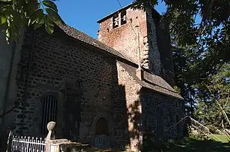 The templar preceptory of Celles | |
Location of Celles | |
 Celles  Celles | |
| Coordinates: 45°06′57″N 2°57′17″E / 45.1158°N 2.9547°E | |
| Country | France |
| Region | Auvergne-Rhône-Alpes |
| Department | Cantal |
| Arrondissement | Saint-Flour |
| Canton | Murat |
Area 1 | 18.35 km2 (7.08 sq mi) |
| Population (2022)[1] | 217 |
| • Density | 12/km2 (31/sq mi) |
| Time zone | UTC+01:00 (CET) |
| • Summer (DST) | UTC+02:00 (CEST) |
| INSEE/Postal code | 15031 /15170 |
| Elevation | 800–1,075 m (2,625–3,527 ft) (avg. 880 m or 2,890 ft) |
| 1 French Land Register data, which excludes lakes, ponds, glaciers > 1 km2 (0.386 sq mi or 247 acres) and river estuaries. | |
Celles (French pronunciation: [sɛl] ⓘ; Auvergnat: Cèlas) is a commune in the Cantal department in south-central France. Between December 2016 and January 2025, it was part of Neussargues en Pinatelle.[2][3]
Population
| Year | Pop. | ±% |
|---|---|---|
| 1962 | 240 | — |
| 1968 | 281 | +17.1% |
| 1975 | 257 | −8.5% |
| 1982 | 229 | −10.9% |
| 1990 | 221 | −3.5% |
| 1999 | 239 | +8.1% |
| 2008 | 235 | −1.7% |
See also
References
- ^ "Populations de référence 2022" (in French). The National Institute of Statistics and Economic Studies. 19 December 2024.
- ^ Arrêté préfectoral 21 September 2016 (in French)
- ^ "Neussargues en Pinatelle : modification des limites territoriales de la commune". Les services de l'État dans le Cantal (in French). Retrieved 2025-01-03.
Wikimedia Commons has media related to Celles (Cantal).