Quœux-Haut-Maînil
Quœux-Haut-Maînil | |
|---|---|
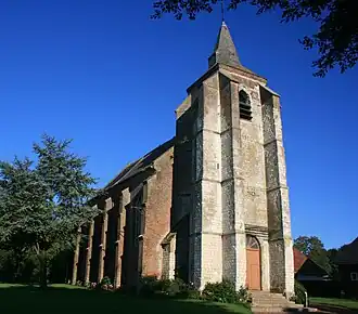 The church of Quœux-Haut-Maînil | |
 Coat of arms | |
Location of Quœux-Haut-Maînil | |
 Quœux-Haut-Maînil  Quœux-Haut-Maînil | |
| Coordinates: 50°18′06″N 2°06′42″E / 50.3017°N 2.1117°E | |
| Country | France |
| Region | Hauts-de-France |
| Department | Pas-de-Calais |
| Arrondissement | Arras |
| Canton | Auxi-le-Château |
| Intercommunality | CC Ternois |
| Government | |
| • Mayor (2020–2026) | Fredy Tirmarche[1] |
Area 1 | 12.01 km2 (4.64 sq mi) |
| Population (2022)[2] | 215 |
| • Density | 18/km2 (46/sq mi) |
| Time zone | UTC+01:00 (CET) |
| • Summer (DST) | UTC+02:00 (CEST) |
| INSEE/Postal code | 62683 /62390 |
| Elevation | 77–139 m (253–456 ft) (avg. 131 m or 430 ft) |
| 1 French Land Register data, which excludes lakes, ponds, glaciers > 1 km2 (0.386 sq mi or 247 acres) and river estuaries. | |
Quœux-Haut-Maînil (French pronunciation: [kø o mɛnil]) is a commune in the Pas-de-Calais department in the Hauts-de-France region of France.[3]
Geography
Quœux-Haut-Maînil is situated 33 miles (53 km) west of Arras, at the junction of the D101 and D117 roads.
Population
| Year | Pop. | ±% p.a. |
|---|---|---|
| 1968 | 334 | — |
| 1975 | 309 | −1.11% |
| 1982 | 328 | +0.86% |
| 1990 | 273 | −2.27% |
| 1999 | 262 | −0.46% |
| 2007 | 240 | −1.09% |
| 2012 | 246 | +0.50% |
| 2017 | 257 | +0.88% |
| Source: INSEE[4] | ||
Places of interest
- The unusually large church of St.Jacques, dating from the fifteenth century.
- The church of St. Thomas.
- Traces of an old castle.
See also
References
- ^ "Répertoire national des élus: les maires" (in French). data.gouv.fr, Plateforme ouverte des données publiques françaises. 13 September 2022.
- ^ "Populations de référence 2022" (in French). The National Institute of Statistics and Economic Studies. 19 December 2024.
- ^ INSEE commune file
- ^ Population en historique depuis 1968, INSEE
Wikimedia Commons has media related to Quœux-Haut-Maînil.