Boisdinghem
Boisdinghem | |
|---|---|
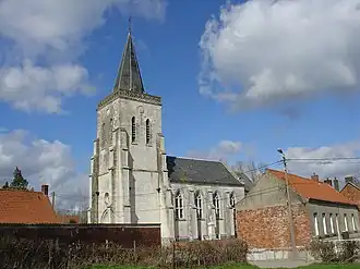 The church of Boisdinghem | |
 Coat of arms | |
Location of Boisdinghem | |
 Boisdinghem  Boisdinghem | |
| Coordinates: 50°44′58″N 2°05′41″E / 50.7494°N 2.0947°E | |
| Country | France |
| Region | Hauts-de-France |
| Department | Pas-de-Calais |
| Arrondissement | Saint-Omer |
| Canton | Lumbres |
| Intercommunality | Pays de Lumbres |
| Government | |
| • Mayor (2020–2026) | Michel Lheureux[1] |
Area 1 | 3.13 km2 (1.21 sq mi) |
| Population (2022)[2] | 255 |
| • Density | 81/km2 (210/sq mi) |
| Time zone | UTC+01:00 (CET) |
| • Summer (DST) | UTC+02:00 (CEST) |
| INSEE/Postal code | 62149 /62500 |
| Elevation | 104–167 m (341–548 ft) (avg. 166 m or 545 ft) |
| 1 French Land Register data, which excludes lakes, ponds, glaciers > 1 km2 (0.386 sq mi or 247 acres) and river estuaries. | |
Boisdinghem (French pronunciation: [bwadɛ̃ɡɑ̃]; Picard: Bodinghin; Dutch: Bodingem) is a commune in the Pas-de-Calais department in the Hauts-de-France region in northern France.[3]
Geography
A small village situated 5 miles (8 km) west of Saint-Omer, on the D206 road.
Population
| Year | Pop. | ±% p.a. |
|---|---|---|
| 1968 | 149 | — |
| 1975 | 141 | −0.79% |
| 1982 | 158 | +1.64% |
| 1990 | 176 | +1.36% |
| 1999 | 191 | +0.91% |
| 2009 | 226 | +1.70% |
| 2014 | 242 | +1.38% |
| 2020 | 244 | +0.14% |
| Source: INSEE[4] | ||
Sights
- The church of St. Omer, dating from the seventeenth century
Notable residents
- Alphonse Pinart (1852-1911), explorer, philologist, and ethnographer
See also
References
- ^ "Répertoire national des élus: les maires". data.gouv.fr, Plateforme ouverte des données publiques françaises (in French). 2 December 2020.
- ^ "Populations de référence 2022" (in French). The National Institute of Statistics and Economic Studies. 19 December 2024.
- ^ INSEE commune file
- ^ Population en historique depuis 1968, INSEE
Wikimedia Commons has media related to Boisdinghem.