Bihucourt
Bihucourt | |
|---|---|
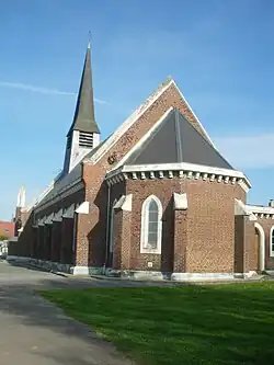 The church of Bihucourt | |
 Coat of arms | |
Location of Bihucourt | |
 Bihucourt  Bihucourt | |
| Coordinates: 50°07′36″N 2°48′02″E / 50.1267°N 2.8006°E | |
| Country | France |
| Region | Hauts-de-France |
| Department | Pas-de-Calais |
| Arrondissement | Arras |
| Canton | Bapaume |
| Intercommunality | CC du Sud-Artois |
| Government | |
| • Mayor (2020–2026) | Benoît-Vincent Caille[1] |
Area 1 | 4.67 km2 (1.80 sq mi) |
| Population (2022)[2] | 310 |
| • Density | 66/km2 (170/sq mi) |
| Time zone | UTC+01:00 (CET) |
| • Summer (DST) | UTC+02:00 (CEST) |
| INSEE/Postal code | 62131 /62121 |
| Elevation | 102–131 m (335–430 ft) (avg. 116 m or 381 ft) |
| 1 French Land Register data, which excludes lakes, ponds, glaciers > 1 km2 (0.386 sq mi or 247 acres) and river estuaries. | |
Bihucourt (French pronunciation: [bi.ykuʁ]) is a commune in the Pas-de-Calais department in the Hauts-de-France region in northern France.[3]
Bihucourt was struck by an EF3 tornado on 23 October 2022, causing significant damage in the area.
Geography
A farming village located 11 miles (18 km) south of Arras at the junction of the D31 and the D7.
Population
| Year | Pop. | ±% p.a. |
|---|---|---|
| 1968 | 328 | — |
| 1975 | 262 | −3.16% |
| 1982 | 289 | +1.41% |
| 1990 | 307 | +0.76% |
| 1999 | 305 | −0.07% |
| 2009 | 366 | +1.84% |
| 2014 | 346 | −1.12% |
| 2020 | 338 | −0.39% |
| Source: INSEE[4] | ||
Sights
- The church of St. Vaast, which, like most of the village, was rebuilt after the ravages of World War I.
- The war memorial.
See also
References
- ^ "Répertoire national des élus: les maires". data.gouv.fr, Plateforme ouverte des données publiques françaises (in French). 2 December 2020.
- ^ "Populations de référence 2022" (in French). The National Institute of Statistics and Economic Studies. 19 December 2024.
- ^ INSEE commune file
- ^ Population en historique depuis 1968, INSEE
Wikimedia Commons has media related to Bihucourt.