Labeaume
Labeaume
La Bauma (Occitan) | |
|---|---|
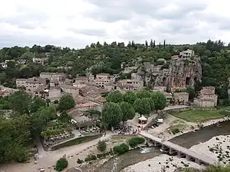 A view of Labeaume on the Beaume River | |
 Coat of arms | |
Location of Labeaume | |
 Labeaume  Labeaume | |
| Coordinates: 44°27′00″N 4°18′26″E / 44.45°N 4.3072°E | |
| Country | France |
| Region | Auvergne-Rhône-Alpes |
| Department | Ardèche |
| Arrondissement | Largentière |
| Canton | Vallon-Pont-d'Arc |
| Government | |
| • Mayor (2020–2026) | Gérard Marron[1] |
Area 1 | 17.76 km2 (6.86 sq mi) |
| Population (2022)[2] | 684 |
| • Density | 39/km2 (100/sq mi) |
| Time zone | UTC+01:00 (CET) |
| • Summer (DST) | UTC+02:00 (CEST) |
| INSEE/Postal code | 07115 /07120 |
| Elevation | 99–265 m (325–869 ft) (avg. 140 m or 460 ft) |
| 1 French Land Register data, which excludes lakes, ponds, glaciers > 1 km2 (0.386 sq mi or 247 acres) and river estuaries. | |
Labeaume (French pronunciation: [labom]; Occitan: La Bauma) is a commune in the Ardèche department in the Auvergne-Rhône-Alpes region in Southern France.
A little different in nature from other villages of character, Labeaume is situated around an open square with a church and has a handful of old streets to explore, with ancient houses lining narrow alleys.[3]
Demographics
| Year | Pop. | ±% p.a. |
|---|---|---|
| 1968 | 346 | — |
| 1975 | 357 | +0.45% |
| 1982 | 405 | +1.82% |
| 1990 | 455 | +1.47% |
| 1999 | 493 | +0.90% |
| 2009 | 607 | +2.10% |
| 2014 | 655 | +1.53% |
| 2020 | 674 | +0.48% |
| Source: INSEE[4] | ||
See also
References
- ^ "Répertoire national des élus: les maires". data.gouv.fr, Plateforme ouverte des données publiques françaises (in French). 2 December 2020.
- ^ "Populations de référence 2022" (in French). The National Institute of Statistics and Economic Studies. 19 December 2024.
- ^ "Information"
- ^ Population en historique depuis 1968, INSEE
Wikimedia Commons has media related to Labeaume.