Eclassan
Eclassan | |
|---|---|
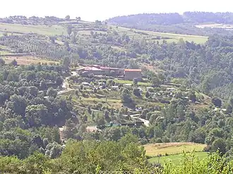 Petit Chaleat, in Eclassan | |
Location of Eclassan | |
 Eclassan  Eclassan | |
| Coordinates: 45°09′32″N 4°45′43″E / 45.1589°N 4.7619°E | |
| Country | France |
| Region | Auvergne-Rhône-Alpes |
| Department | Ardèche |
| Arrondissement | Tournon-sur-Rhône |
| Canton | Sarras |
| Government | |
| • Mayor (2021–2026) | Pierre Madinier[1] |
Area 1 | 15.93 km2 (6.15 sq mi) |
| Population (2022)[2] | 1,046 |
| • Density | 66/km2 (170/sq mi) |
| Time zone | UTC+01:00 (CET) |
| • Summer (DST) | UTC+02:00 (CEST) |
| INSEE/Postal code | 07084 /07370 |
| Elevation | 273–530 m (896–1,739 ft) (avg. 400 m or 1,300 ft) |
| 1 French Land Register data, which excludes lakes, ponds, glaciers > 1 km2 (0.386 sq mi or 247 acres) and river estuaries. | |
Eclassan (French pronunciation: [eklasɑ̃]; also Éclassan) is a commune in the Ardèche department in southern France.
Population
| Year | Pop. | ±% |
|---|---|---|
| 1962 | 528 | — |
| 1968 | 598 | +13.3% |
| 1975 | 533 | −10.9% |
| 1982 | 573 | +7.5% |
| 1990 | 633 | +10.5% |
| 1999 | 702 | +10.9% |
| 2008 | 864 | +23.1% |
See also
References
- ^ "Répertoire national des élus: les maires". data.gouv.fr, Plateforme ouverte des données publiques françaises (in French). 1 February 2022.
- ^ "Populations de référence 2022" (in French). The National Institute of Statistics and Economic Studies. 19 December 2024.
Wikimedia Commons has media related to Eclassan.