Chalais, Charente
Chalais | |
|---|---|
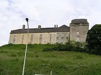 Chateau | |
.svg.png) Coat of arms | |
Location of Chalais | |
 Chalais  Chalais | |
| Coordinates: 45°16′26″N 0°02′24″E / 45.2739°N 0.04°E | |
| Country | France |
| Region | Nouvelle-Aquitaine |
| Department | Charente |
| Arrondissement | Angoulême |
| Canton | Tude-et-Lavalette |
| Intercommunality | Lavalette Tude Dronne |
| Government | |
| • Mayor (2024–2026) | Jacques Blanchet[1] |
Area 1 | 17.58 km2 (6.79 sq mi) |
| Population (2022)[2] | 1,799 |
| • Density | 100/km2 (270/sq mi) |
| Time zone | UTC+01:00 (CET) |
| • Summer (DST) | UTC+02:00 (CEST) |
| INSEE/Postal code | 16073 /16210 |
| Elevation | 35–130 m (115–427 ft) |
| 1 French Land Register data, which excludes lakes, ponds, glaciers > 1 km2 (0.386 sq mi or 247 acres) and river estuaries. | |
Chalais (French pronunciation: [ʃalɛ]) is a commune in the Charente department in southwestern France. It is the southernmost town in the Charente with over 1,000 people. It lies along the river Tude.
Population
|
| |||||||||||||||||||||||||||||||||||||||||||||||||||||||||||||||||||||||||||||||||||||||||||||||||||||||||||||||
| Source: EHESS[3] and INSEE (1968-2017)[4] | ||||||||||||||||||||||||||||||||||||||||||||||||||||||||||||||||||||||||||||||||||||||||||||||||||||||||||||||||
See also
References
- ^ "Répertoire national des élus: les maires" (in French). data.gouv.fr, Plateforme ouverte des données publiques françaises. 16 April 2024.
- ^ "Populations de référence 2022" (in French). The National Institute of Statistics and Economic Studies. 19 December 2024.
- ^ Des villages de Cassini aux communes d'aujourd'hui: Commune data sheet Chalais, EHESS (in French).
- ^ Population en historique depuis 1968, INSEE
Wikimedia Commons has media related to Chalais (Charente).