Aubusson, Orne
Aubusson | |
|---|---|
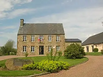 The town hall in Aubusson | |
.svg.png) Coat of arms | |
Location of Aubusson | |
 Aubusson  Aubusson | |
| Coordinates: 48°47′06″N 0°33′05″W / 48.785°N 0.5514°W | |
| Country | France |
| Region | Normandy |
| Department | Orne |
| Arrondissement | Argentan |
| Canton | Flers-2 |
| Intercommunality | CA Flers Agglo |
| Government | |
| • Mayor (2020–2026) | Sylvain Boulant[1] |
Area 1 | 3.90 km2 (1.51 sq mi) |
| Population (2022)[2] | 396 |
| • Density | 100/km2 (260/sq mi) |
| Time zone | UTC+01:00 (CET) |
| • Summer (DST) | UTC+02:00 (CEST) |
| INSEE/Postal code | 61011 /61100 |
| Elevation | 168–272 m (551–892 ft) (avg. 264 m or 866 ft) |
| 1 French Land Register data, which excludes lakes, ponds, glaciers > 1 km2 (0.386 sq mi or 247 acres) and river estuaries. | |
Aubusson (French pronunciation: [obysɔ̃] ⓘ) is a commune in the Orne department in northwestern France.
Geography
The commune is part of the area known as Suisse Normande.[3]
The commune is made up of the following collection of villages and hamlets, La Maillardière,Le Hamel du Bois, Le Coudray, La Guermondière and Aubusson.[4]
The commune has 2 watercourses running through it a river, La Vere and 1 stream the Aubusson.
Neighbouring communes[4] | |
|---|---|
Population
| Year | Pop. | ±% p.a. |
|---|---|---|
| 1968 | 189 | — |
| 1975 | 221 | +2.26% |
| 1982 | 314 | +5.15% |
| 1990 | 329 | +0.59% |
| 1999 | 335 | +0.20% |
| 2009 | 417 | +2.21% |
| 2014 | 425 | +0.38% |
| 2020 | 408 | −0.68% |
| Source: INSEE[5] | ||
See also
References
- ^ "Répertoire national des élus: les maires". data.gouv.fr, Plateforme ouverte des données publiques françaises (in French). 2 December 2020.
- ^ "Populations de référence 2022" (in French). The National Institute of Statistics and Economic Studies. 19 December 2024.
- ^ "Map of Suisse Normande" (PDF).
- ^ a b "Google Maps". Google Maps.
- ^ Population en historique depuis 1968, INSEE
Wikimedia Commons has media related to Aubusson (Orne).