Zvole (Žďár nad Sázavou District)
Zvole | |
|---|---|
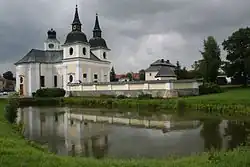 Church of Saint Wenceslaus | |
 Flag  Coat of arms | |
 Zvole Location in the Czech Republic | |
| Coordinates: 49°29′40″N 16°10′30″E / 49.49444°N 16.17500°E | |
| Country | |
| Region | Vysočina |
| District | Žďár nad Sázavou |
| First mentioned | 1349 |
| Area | |
• Total | 17.06 km2 (6.59 sq mi) |
| Elevation | 529 m (1,736 ft) |
| Population (2025-01-01)[1] | |
• Total | 651 |
| • Density | 38/km2 (99/sq mi) |
| Time zone | UTC+1 (CET) |
| • Summer (DST) | UTC+2 (CEST) |
| Postal codes | 592 51, 592 56 |
| Website | www |
Zvole is a municipality and village in Žďár nad Sázavou District in the Vysočina Region of the Czech Republic. It has about 700 inhabitants.
Zvole lies approximately 19 kilometres (12 mi) south-east of Žďár nad Sázavou, 44 kilometres (27 mi) east of Jihlava, and 142 kilometres (88 mi) south-east of Prague.
Administrative division
Zvole consists of three municipal parts (in brackets population according to the 2021 census):[2]
- Zvole (329)
- Branišov (218)
- Olešínky (99)
Demographics
| Year | Pop. | ±% |
|---|---|---|
| 1869 | 1,075 | — |
| 1880 | 1,057 | −1.7% |
| 1890 | 1,077 | +1.9% |
| 1900 | 1,052 | −2.3% |
| 1910 | 1,067 | +1.4% |
| 1921 | 1,042 | −2.3% |
| 1930 | 1,002 | −3.8% |
| 1950 | 754 | −24.8% |
| 1961 | 759 | +0.7% |
| 1970 | 690 | −9.1% |
| 1980 | 678 | −1.7% |
| 1991 | 641 | −5.5% |
| 2001 | 631 | −1.6% |
| 2011 | 604 | −4.3% |
| 2021 | 646 | +7.0% |
| Source: Censuses[3][4] | ||
References
- ^ "Population of Municipalities – 1 January 2025". Czech Statistical Office. 2025-05-16.
- ^ "Public Census 2021 – basic data". Public Database (in Czech). Czech Statistical Office. 2022.
- ^ "Historický lexikon obcí České republiky 1869–2011" (in Czech). Czech Statistical Office. 2015-12-21.
- ^ "Population Census 2021: Population by sex". Public Database. Czech Statistical Office. 2021-03-27.
External links
Wikimedia Commons has media related to Zvole (Žďár nad Sázavou District).