Vepřová
Vepřová | |
|---|---|
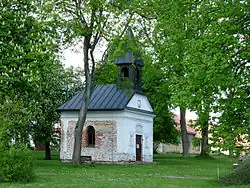 Chapel of the Holy Trinity | |
 Flag  Coat of arms | |
 Vepřová Location in the Czech Republic | |
| Coordinates: 49°36′45″N 15°49′39″E / 49.61250°N 15.82750°E | |
| Country | |
| Region | Vysočina |
| District | Žďár nad Sázavou |
| First mentioned | 1502 |
| Area | |
• Total | 10.44 km2 (4.03 sq mi) |
| Elevation | 630 m (2,070 ft) |
| Population (2025-01-01)[1] | |
• Total | 445 |
| • Density | 43/km2 (110/sq mi) |
| Time zone | UTC+1 (CET) |
| • Summer (DST) | UTC+2 (CEST) |
| Postal code | 592 11 |
| Website | www |
Vepřová is a municipality and village in Žďár nad Sázavou District in the Vysočina Region of the Czech Republic. It has about 400 inhabitants.
Vepřová lies approximately 10 kilometres (6 mi) north-west of Žďár nad Sázavou, 30 km (19 mi) north-east of Jihlava, and 114 km (71 mi) south-east of Prague.
Demographics
| Year | Pop. | ±% |
|---|---|---|
| 1869 | 460 | — |
| 1880 | 474 | +3.0% |
| 1890 | 492 | +3.8% |
| 1900 | 494 | +0.4% |
| 1910 | 510 | +3.2% |
| 1921 | 498 | −2.4% |
| 1930 | 414 | −16.9% |
| 1950 | 347 | −16.2% |
| 1961 | 360 | +3.7% |
| 1970 | 366 | +1.7% |
| 1980 | 390 | +6.6% |
| 1991 | 367 | −5.9% |
| 2001 | 387 | +5.4% |
| 2011 | 406 | +4.9% |
| 2021 | 420 | +3.4% |
| Source: Censuses[2][3] | ||
References
- ^ "Population of Municipalities – 1 January 2025". Czech Statistical Office. 2025-05-16.
- ^ "Historický lexikon obcí České republiky 1869–2011" (in Czech). Czech Statistical Office. 2015-12-21.
- ^ "Population Census 2021: Population by sex". Public Database. Czech Statistical Office. 2021-03-27.
External links
Wikimedia Commons has media related to Vepřová.