Studnice (Vyškov District)
Studnice | |
|---|---|
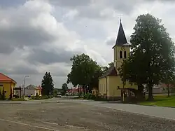 Centre of Studnice | |
 Flag  Coat of arms | |
 Studnice Location in the Czech Republic | |
| Coordinates: 49°22′32″N 16°52′52″E / 49.37556°N 16.88111°E | |
| Country | |
| Region | South Moravian |
| District | Vyškov |
| First mentioned | 1342 |
| Area | |
• Total | 6.36 km2 (2.46 sq mi) |
| Elevation | 569 m (1,867 ft) |
| Population (2025-01-01)[1] | |
• Total | 503 |
| • Density | 79/km2 (200/sq mi) |
| Time zone | UTC+1 (CET) |
| • Summer (DST) | UTC+2 (CEST) |
| Postal code | 683 08 |
| Website | www |
Studnice is a municipality and village in Vyškov District in the South Moravian Region of the Czech Republic. It has about 500 inhabitants.
Studnice lies approximately 15 kilometres (9 mi) north-west of Vyškov, 28 km (17 mi) north-east of Brno, and 194 km (121 mi) south-east of Prague.
Administrative division
Studnice consists of two municipal parts (in brackets population according to the 2021 census):[2]
- Studnice (400)
- Odrůvky (61)
Demographics
| Year | Pop. | ±% |
|---|---|---|
| 1869 | 991 | — |
| 1880 | 1,050 | +6.0% |
| 1890 | 1,097 | +4.5% |
| 1900 | 1,102 | +0.5% |
| 1910 | 1,175 | +6.6% |
| 1921 | 1,195 | +1.7% |
| 1930 | 1,009 | −15.6% |
| 1950 | 716 | −29.0% |
| 1961 | 837 | +16.9% |
| 1970 | 805 | −3.8% |
| 1980 | 668 | −17.0% |
| 1991 | 572 | −14.4% |
| 2001 | 508 | −11.2% |
| 2011 | 466 | −8.3% |
| 2021 | 461 | −1.1% |
| Source: Censuses[3][4] | ||
References
- ^ "Population of Municipalities – 1 January 2025". Czech Statistical Office. 2025-05-16.
- ^ "Public Census 2021 – basic data". Public Database (in Czech). Czech Statistical Office. 2022.
- ^ "Historický lexikon obcí České republiky 1869–2011" (in Czech). Czech Statistical Office. 2015-12-21.
- ^ "Population Census 2021: Population by sex". Public Database. Czech Statistical Office. 2021-03-27.
External links
Wikimedia Commons has media related to Studnice (Vyškov District).