Slavhostice
Slavhostice | |
|---|---|
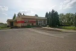 Municipal office and grocery store | |
 Flag  Coat of arms | |
 Slavhostice Location in the Czech Republic | |
| Coordinates: 50°18′32″N 15°20′58″E / 50.30889°N 15.34944°E | |
| Country | |
| Region | Hradec Králové |
| District | Jičín |
| First mentioned | 1371 |
| Area | |
• Total | 5.85 km2 (2.26 sq mi) |
| Elevation | 258 m (846 ft) |
| Population (2025-01-01)[1] | |
• Total | 130 |
| • Density | 22/km2 (58/sq mi) |
| Time zone | UTC+1 (CET) |
| • Summer (DST) | UTC+2 (CEST) |
| Postal code | 507 32 |
| Website | www |
Slavhostice is a municipality and village in Jičín District in the Hradec Králové Region of the Czech Republic. It has about 100 inhabitants.
Demographics
| Year | Pop. | ±% |
|---|---|---|
| 1869 | 455 | — |
| 1880 | 534 | +17.4% |
| 1890 | 539 | +0.9% |
| 1900 | 526 | −2.4% |
| 1910 | 521 | −1.0% |
| 1921 | 490 | −6.0% |
| 1930 | 505 | +3.1% |
| 1950 | 325 | −35.6% |
| 1961 | 312 | −4.0% |
| 1970 | 273 | −12.5% |
| 1980 | 207 | −24.2% |
| 1991 | 158 | −23.7% |
| 2001 | 145 | −8.2% |
| 2011 | 138 | −4.8% |
| 2021 | 127 | −8.0% |
| Source: Censuses[2][3] | ||
References
- ^ "Population of Municipalities – 1 January 2025". Czech Statistical Office. 2025-05-16.
- ^ "Historický lexikon obcí České republiky 1869–2011" (in Czech). Czech Statistical Office. 2015-12-21.
- ^ "Population Census 2021: Population by sex". Public Database. Czech Statistical Office. 2021-03-27.
External links
Wikimedia Commons has media related to Slavhostice.