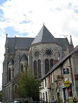
Rougé
Rougé | |
|---|---|
Commune | |
 | |
.svg.png) Coat of arms | |
Location of Rougé | |
 Rougé 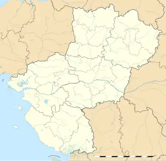 Rougé | |
| Coordinates: 47°47′01″N 1°26′49″W / 47.7836°N 1.4469°W | |
| Country | France |
| Region | Pays de la Loire |
| Department | Loire-Atlantique |
| Arrondissement | Châteaubriant-Ancenis |
| Canton | Châteaubriant |
| Intercommunality | Châteaubriant-Derval |
| Government | |
| • Mayor (2020–2026) | Jean-Michel Duclos[1] |
Area 1 | 56.32 km2 (21.75 sq mi) |
| Population (2022)[2] | 2,152 |
| • Density | 38/km2 (99/sq mi) |
| Time zone | UTC+01:00 (CET) |
| • Summer (DST) | UTC+02:00 (CEST) |
| INSEE/Postal code | 44146 /44660 |
| Elevation | 39–109 m (128–358 ft) |
| 1 French Land Register data, which excludes lakes, ponds, glaciers > 1 km2 (0.386 sq mi or 247 acres) and river estuaries. | |
Rougé (French pronunciation: [ʁuʒe] ⓘ; Breton: Ruzieg) is a commune in the Loire-Atlantique department in western France, near Rennes.
The name "Rougé" comes from the Latin "Rubiacus", means the red place, in reference to the high iron-composition of the ground.
Geography
The river Chère forms small part of the commune's southern border.
Population
|
| ||||||||||||||||||||||||||||||||||||||||||||||||||||||
| Source: EHESS[3] and INSEE (1968-2017)[4] | |||||||||||||||||||||||||||||||||||||||||||||||||||||||
References
- ^ "Répertoire national des élus: les maires" (in French). data.gouv.fr, Plateforme ouverte des données publiques françaises. 13 September 2022.
- ^ "Populations de référence 2022" (in French). The National Institute of Statistics and Economic Studies. 19 December 2024.
- ^ Des villages de Cassini aux communes d'aujourd'hui: Commune data sheet Rougé, EHESS (in French).
- ^ Population en historique depuis 1968, INSEE
See also
Wikimedia Commons has media related to Rougé.