Mutěnice (Strakonice District)
Mutěnice | |
|---|---|
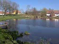 Okoun Pond in the centre of Mutěnice | |
_-_Flag.jpg) Flag _-_CoA.png) Coat of arms | |
 Mutěnice Location in the Czech Republic | |
| Coordinates: 49°14′23″N 13°53′48″E / 49.23972°N 13.89667°E | |
| Country | |
| Region | South Bohemian |
| District | Strakonice |
| First mentioned | 1243 |
| Area | |
• Total | 2.28 km2 (0.88 sq mi) |
| Elevation | 406 m (1,332 ft) |
| Population (2025-01-01)[1] | |
• Total | 279 |
| • Density | 120/km2 (320/sq mi) |
| Time zone | UTC+1 (CET) |
| • Summer (DST) | UTC+2 (CEST) |
| Postal code | 386 01 |
| Website | www |
Mutěnice is a municipality and village in Strakonice District in the South Bohemian Region of the Czech Republic. It has about 300 inhabitants.
Mutěnice lies approximately 3 kilometres (2 mi) south-west of Strakonice, 52 km (32 mi) north-west of České Budějovice, and 102 km (63 mi) south of Prague.
Demographics
| Year | Pop. | ±% |
|---|---|---|
| 1869 | 226 | — |
| 1880 | 247 | +9.3% |
| 1890 | 230 | −6.9% |
| 1900 | 216 | −6.1% |
| 1910 | 195 | −9.7% |
| 1921 | 220 | +12.8% |
| 1930 | 277 | +25.9% |
| 1950 | 286 | +3.2% |
| 1961 | 294 | +2.8% |
| 1970 | 269 | −8.5% |
| 1980 | 217 | −19.3% |
| 1991 | 161 | −25.8% |
| 2001 | 191 | +18.6% |
| 2011 | 208 | +8.9% |
| 2021 | 254 | +22.1% |
| Source: Censuses[2][3] | ||
References
- ^ "Population of Municipalities – 1 January 2025". Czech Statistical Office. 2025-05-16.
- ^ "Historický lexikon obcí České republiky 1869–2011" (in Czech). Czech Statistical Office. 2015-12-21.
- ^ "Population Census 2021: Population by sex". Public Database. Czech Statistical Office. 2021-03-27.
External links
Wikimedia Commons has media related to Mutěnice (Strakonice District).