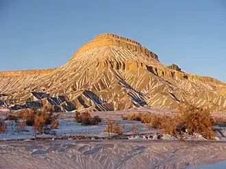
Mount Garfield (Mesa County, Colorado)
| Mount Garfield | |
|---|---|
 Southwest aspect | |
| Highest point | |
| Elevation | 6,765 ft (2,062 m)[1] |
| Prominence | 445 ft (136 m)[1] |
| Isolation | 5.54 mi (8.92 km)[2] |
| Coordinates | 39°07′29″N 108°24′37″W / 39.124624°N 108.410301°W[1] |
| Geography | |
 Mount Garfield Location in Colorado  Mount Garfield Mount Garfield (the United States) | |
| Location | Mesa County, Colorado, U.S. |
| Parent range | Colorado Plateau |
| Topo map | USGS Clifton |
| Geology | |
| Rock age | Late Cretaceous |
| Rock type(s) | sandstone, mudstone, shale |
| Climbing | |
| Easiest route | class 1 hiking[2] |
Mt. Garfield[3] is the high point of the Book Cliffs, east-northeast of Grand Junction, and overlooking the town of Palisade. Two classic hiking trails ascend the mountain. The mountain was named after President James Garfield a year after Garfield's death. The mountain is composed of Mesaverde Group overlaying Mancos Shale.
.jpg)
References
- ^ a b c "Mount Garfield, Colorado". Peakbagger.com. Retrieved 2021-03-26.
- ^ a b "Garfield, Mount - 6,780' CO". listsofjohn.com. Retrieved 2021-03-26.
- ^ "Mount Garfield". Geographic Names Information System. United States Geological Survey, United States Department of the Interior.