Jacque Peak
| Jacque Peak | |
|---|---|
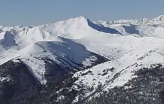 Jacque Peak viewed from Peak 8 | |
| Highest point | |
| Elevation | 13,211 ft (4,027 m)[1][2] |
| Prominence | 2,065 ft (629 m)[2] |
| Isolation | 4.52 mi (7.27 km)[2] |
| Listing | |
| Coordinates | 39°27′16″N 106°11′51″W / 39.4544315°N 106.1975234°W[3] |
| Geography | |
 Jacque Peak | |
| Location | Summit County, Colorado, U.S.[3] |
| Parent range | Gore Range[2] |
| Topo map(s) | USGS 7.5' topographic map Copper Mountain, Colorado[3] |
Jacque Peak is a high and prominent mountain summit in the Gore Range of the Rocky Mountains of North America. The 13,211-foot (4,027 m) thirteener is located in the White River National Forest, 1.6 miles (2.5 km) south by east (bearing 173°) of the resort community of Copper Mountain in Summit County, Colorado, United States.[1][2][3]
See also
References
- ^ a b The elevation of Jacque Peak includes an adjustment of +1.866 m (+6.12 ft) from NGVD 29 to NAVD 88.
- ^ a b c d e "Jacque Peak, Colorado". Peakbagger.com. Retrieved December 8, 2014.
- ^ a b c d "Jacque Peak". Geographic Names Information System. United States Geological Survey, United States Department of the Interior. Retrieved December 8, 2014.
External links
|
Denver (capital) | |
| Topics |
|
| Society | |
| Cities |
|
| Counties |
|
| Regions |
|