Taylor Peak (Grand County, Colorado)
| Taylor Peak | |
|---|---|
 Taylor Peak | |
| Highest point | |
| Elevation | 13,158 ft (4,011 m)[1][2] |
| Prominence | 413 ft (126 m)[2] |
| Isolation | 1.03 mi (1.66 km)[2] |
| Coordinates | 40°16′28″N 105°40′51″W / 40.2744291°N 105.680839°W[3] |
| Geography | |
 Taylor Peak Location in Colorado  Taylor Peak Location in the United States | |
| Location | Rocky Mountain National Park on the Continental Divide between Grand and Larimer counties, Colorado, United States[3] |
| Parent range | Front Range[2] |
| Topo map(s) | USGS 7.5' topographic map McHenrys Peak, Colorado[3] |
| Climbing | |
| Easiest route | Scramble |
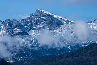
Taylor Peak, elevation 13,158 ft (4,011 m), is a summit in the Front Range of north central Colorado. The peak is in Rocky Mountain National Park at the head of Loch Vale and just north of Taylor Glacier.[4]
Historical names
- Taylor Peak – 1932 [3]
- The Bangs
.jpg)
See also
- List of Colorado mountain ranges
- List of Colorado mountain summits
- List of Colorado county high points
References
- ^ The elevation of Taylor Peak includes an adjustment of +1.623 m (+5.32 ft) from NGVD 29 to NAVD 88.
- ^ a b c d "Taylor Peak, Colorado". Peakbagger.com. Retrieved November 6, 2014.
- ^ a b c d "Taylor Peak". Geographic Names Information System. United States Geological Survey, United States Department of the Interior. Retrieved November 6, 2014.
- ^ McHenrys Peak, CO (Map). TopoQwest (United States Geological Survey Maps). Retrieved August 21, 2012.
External links
 Media related to Taylor Peak at Wikimedia Commons
Denver (capital) | |
| Topics |
|
| Society | |
| Cities |
|
| Counties |
|
| Regions |
|