Leménil-Mitry
Leménil-Mitry | |
|---|---|
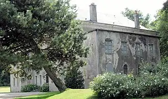 The chateau in Leménil-Mitry | |
 Coat of arms | |
Location of Leménil-Mitry | |
 Leménil-Mitry  Leménil-Mitry | |
| Coordinates: 48°27′07″N 6°15′09″E / 48.452°N 6.2525°E | |
| Country | France |
| Region | Grand Est |
| Department | Meurthe-et-Moselle |
| Arrondissement | Nancy |
| Canton | Meine au Saintois |
| Intercommunality | Pays du Saintois |
| Government | |
| • Mayor (2020–2026) | Jean-Hyacinthe de Mitry[1] |
Area 1 | 3.43 km2 (1.32 sq mi) |
| Population (2022)[2] | 2 |
| • Density | 0.58/km2 (1.5/sq mi) |
| Time zone | UTC+01:00 (CET) |
| • Summer (DST) | UTC+02:00 (CEST) |
| INSEE/Postal code | 54310 /54740 |
| Elevation | 280–360 m (920–1,180 ft) (avg. 321 m or 1,053 ft) |
| 1 French Land Register data, which excludes lakes, ponds, glaciers > 1 km2 (0.386 sq mi or 247 acres) and river estuaries. | |
Leménil-Mitry (French pronunciation: [ləmenil mitʁi]) is a commune in the Meurthe-et-Moselle department in north-eastern metropolitan France.[3]
As of 2021, it had only two inhabitants, making it one of the least-inhabited communes in France.[4]
Population
| Year | Pop. | ±% p.a. |
|---|---|---|
| 1968 | 4 | — |
| 1975 | 5 | +3.24% |
| 1982 | 4 | −3.14% |
| 1990 | 2 | −8.30% |
| 1999 | 2 | +0.00% |
| 2010 | 3 | +3.75% |
| 2015 | 3 | +0.00% |
| 2021 | 2 | −6.53% |
| Source: INSEE[4] | ||
See also
References
- ^ "Répertoire national des élus: les maires". data.gouv.fr, Plateforme ouverte des données publiques françaises (in French). 9 August 2021.
- ^ "Populations de référence 2022" (in French). The National Institute of Statistics and Economic Studies. 19 December 2024.
- ^ Commune de Leménil-Mitry (54310), INSEE
- ^ a b Full set of local data - Municipality of Leménil-Mitry (54310), INSEE
Wikimedia Commons has media related to Leménil-Mitry.