Lançon, Ardennes
Lançon | |
|---|---|
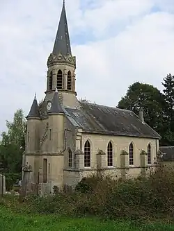 The church in Lançon | |
 Coat of arms | |
Location of Lançon | |
 Lançon  Lançon | |
| Coordinates: 49°16′33″N 4°52′29″E / 49.2758°N 4.8747°E | |
| Country | France |
| Region | Grand Est |
| Department | Ardennes |
| Arrondissement | Vouziers |
| Canton | Attigny |
| Intercommunality | Argonne Ardennaise |
| Government | |
| • Mayor (2020–2026) | Eric Haulin[1] |
Area 1 | 8.24 km2 (3.18 sq mi) |
| Population (2022)[2] | 31 |
| • Density | 3.8/km2 (9.7/sq mi) |
| Time zone | UTC+01:00 (CET) |
| • Summer (DST) | UTC+02:00 (CEST) |
| INSEE/Postal code | 08245 /08250 |
| Elevation | 107–218 m (351–715 ft) (avg. 115 m or 377 ft) |
| 1 French Land Register data, which excludes lakes, ponds, glaciers > 1 km2 (0.386 sq mi or 247 acres) and river estuaries. | |
Lançon (French pronunciation: [lɑ̃sɔ̃]) is a commune in the Ardennes department in northern France.
Population
| Year | Pop. | ±% |
|---|---|---|
| 1962 | 16 | — |
| 1968 | 43 | +168.8% |
| 1975 | 43 | +0.0% |
| 1982 | 34 | −20.9% |
| 1990 | 41 | +20.6% |
| 1999 | 40 | −2.4% |
| 2008 | 40 | +0.0% |
See also
References
- ^ "Répertoire national des élus: les maires". data.gouv.fr, Plateforme ouverte des données publiques françaises (in French). 2 December 2020.
- ^ "Populations de référence 2022" (in French). The National Institute of Statistics and Economic Studies. 19 December 2024.
Wikimedia Commons has media related to Lançon, Ardennes.