Jefferson Township, Washington County, Indiana
Jefferson Township | |
|---|---|
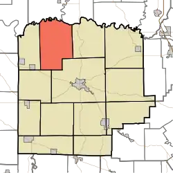 Location in Washington County | |
| Coordinates: 38°42′56″N 86°11′44″W / 38.71556°N 86.19556°W | |
| Country | United States |
| State | Indiana |
| County | Washington |
| Government | |
| • Type | Indiana township |
| Area | |
• Total | 48.74 sq mi (126.2 km2) |
| • Land | 48.1 sq mi (125 km2) |
| • Water | 0.64 sq mi (1.7 km2) 1.31% |
| Elevation | 551 ft (168 m) |
| Population (2020) | |
• Total | 830 |
| • Density | 17/sq mi (6.6/km2) |
| ZIP codes | 47108, 47167 47281 |
| GNIS feature ID | 0453501 |
Jefferson Township is one of thirteen townships in Washington County, Indiana, United States. As of the 2020 census, its population was 830.[1]
| Census | Pop. | Note | %± |
|---|---|---|---|
| 1890 | 1,448 | — | |
| 1900 | 1,450 | 0.1% | |
| 1910 | 1,240 | −14.5% | |
| 1920 | 1,047 | −15.6% | |
| 1930 | 852 | −18.6% | |
| 1940 | 932 | 9.4% | |
| 1950 | 684 | −26.6% | |
| 1960 | 698 | 2.0% | |
| 1970 | 728 | 4.3% | |
| 1980 | 836 | 14.8% | |
| 1990 | 944 | 12.9% | |
| 2000 | 841 | −10.9% | |
| 2010 | 920 | 9.4% | |
| 2020 | 830 | −9.8% | |
| Source: US Decennial Census[2] | |||
Geography
According to the 2010 census, the township has a total area of 48.74 square miles (126.2 km2), of which 48.1 square miles (125 km2) (or 98.69%) is land and 0.64 square miles (1.7 km2) (or 1.31%) is water.[3]
Unincorporated towns
- Haleysbury at 38°44′31″N 86°09′03″W / 38.741999°N 86.150814°W
- McKinley at 38°44′41″N 86°12′38″W / 38.744777°N 86.210538°W
- Prowsville at 38°40′48″N 86°12′06″W / 38.680056°N 86.201649°W
- Rush Creek Valley at 38°41′43″N 86°10′14″W / 38.695333°N 86.170537°W
(This list is based on USGS data and may include former settlements.)
Adjacent townships
- Carr Township, Jackson County (north)
- Driftwood Township, Jackson County (northeast)
- Monroe Township (east)
- Washington Township (southeast)
- Vernon Township (southwest)
- Brown Township (west)
Cemeteries
The township contains these four cemeteries: Covenanter, Pollock, Thompson and Wheeler.
Lakes
- John Hays Lake
School districts
- Salem Community Schools
Political districts
- Indiana's 9th congressional district
- State House District 62
- State Senate District 44
References
- United States Census Bureau 2007 TIGER/Line Shapefiles
- United States Board on Geographic Names (GNIS)
- IndianaMap
- ^ "Township Census Counts: STATS Indiana". www.stats.indiana.edu. Retrieved April 11, 2024.
- ^ "Township Census Counts: STATS Indiana".
- ^ "Population, Housing Units, Area, and Density: 2010 - County -- County Subdivision and Place -- 2010 Census Summary File 1". United States Census. Archived from the original on February 12, 2020. Retrieved May 10, 2013.
External links
Municipalities and communities of Washington County, Indiana, United States | ||
|---|---|---|
| City | 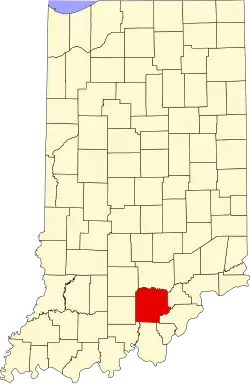 | |
| Towns | ||
| Townships | ||
| CDPs | ||
| Other communities |
| |