Dětkovice (Prostějov District)
Dětkovice | |
|---|---|
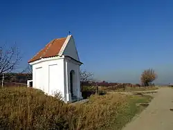 Chapel of Saint Anne | |
 Flag  Coat of arms | |
 Dětkovice Location in the Czech Republic | |
| Coordinates: 49°24′55″N 17°4′56″E / 49.41528°N 17.08222°E | |
| Country | |
| Region | Olomouc |
| District | Prostějov |
| First mentioned | 1355 |
| Area | |
• Total | 5.33 km2 (2.06 sq mi) |
| Elevation | 244 m (801 ft) |
| Population (2025-01-01)[1] | |
• Total | 541 |
| • Density | 100/km2 (260/sq mi) |
| Time zone | UTC+1 (CET) |
| • Summer (DST) | UTC+2 (CEST) |
| Postal code | 798 04 |
| Website | detkoviceupv |
Dětkovice is a municipality and village in Prostějov District in the Olomouc Region of the Czech Republic. It has about 500 inhabitants.
Dětkovice lies approximately 7 kilometres (4 mi) south of Prostějov, 24 km (15 mi) south-west of Olomouc, and 206 km (128 mi) east of Prague.
Demographics
| Year | Pop. | ±% |
|---|---|---|
| 1869 | 616 | — |
| 1880 | 670 | +8.8% |
| 1890 | 663 | −1.0% |
| 1900 | 629 | −5.1% |
| 1910 | 670 | +6.5% |
| 1921 | 641 | −4.3% |
| 1930 | 617 | −3.7% |
| 1950 | 557 | −9.7% |
| 1961 | 556 | −0.2% |
| 1970 | 542 | −2.5% |
| 1980 | 497 | −8.3% |
| 1991 | 471 | −5.2% |
| 2001 | 448 | −4.9% |
| 2011 | 533 | +19.0% |
| 2021 | 535 | +0.4% |
| Source: Censuses[2][3] | ||
References
- ^ "Population of Municipalities – 1 January 2025". Czech Statistical Office. 2025-05-16.
- ^ "Historický lexikon obcí České republiky 1869–2011" (in Czech). Czech Statistical Office. 2015-12-21.
- ^ "Population Census 2021: Population by sex". Public Database. Czech Statistical Office. 2021-03-27.
External links
Wikimedia Commons has media related to Dětkovice (Prostějov District).