Řetůvka
Řetůvka | |
|---|---|
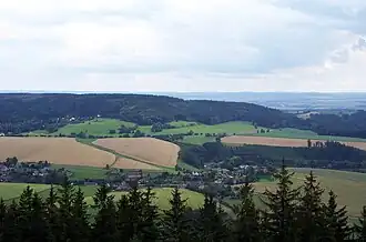 View from the east | |
 Flag  Coat of arms | |
 Řetůvka Location in the Czech Republic | |
| Coordinates: 49°57′21″N 16°21′22″E / 49.95583°N 16.35611°E | |
| Country | |
| Region | Pardubice |
| District | Ústí nad Orlicí |
| First mentioned | 1292 |
| Area | |
• Total | 4.23 km2 (1.63 sq mi) |
| Elevation | 380 m (1,250 ft) |
| Population (2025-01-01)[1] | |
• Total | 282 |
| • Density | 67/km2 (170/sq mi) |
| Time zone | UTC+1 (CET) |
| • Summer (DST) | UTC+2 (CEST) |
| Postal code | 561 41 |
| Website | www |
Řetůvka (German: Ritte) is a municipality and village in Ústí nad Orlicí District in the Pardubice Region of the Czech Republic. It has about 300 inhabitants.
Řetůvka lies approximately 4 kilometres (2 mi) south-west of Ústí nad Orlicí, 43 km (27 mi) east of Pardubice, and 140 km (87 mi) east of Prague.
Demographics
| Year | Pop. | ±% |
|---|---|---|
| 1869 | 606 | — |
| 1880 | 682 | +12.5% |
| 1890 | 665 | −2.5% |
| 1900 | 644 | −3.2% |
| 1910 | 605 | −6.1% |
| 1921 | 535 | −11.6% |
| 1930 | 551 | +3.0% |
| 1950 | 417 | −24.3% |
| 1961 | 400 | −4.1% |
| 1970 | 396 | −1.0% |
| 1980 | 324 | −18.2% |
| 1991 | 248 | −23.5% |
| 2001 | 237 | −4.4% |
| 2011 | 271 | +14.3% |
| 2021 | 244 | −10.0% |
| Source: Censuses[2][3] | ||
References
- ^ "Population of Municipalities – 1 January 2025". Czech Statistical Office. 2025-05-16.
- ^ "Historický lexikon obcí České republiky 1869–2011" (in Czech). Czech Statistical Office. 2015-12-21.
- ^ "Population Census 2021: Population by sex". Public Database. Czech Statistical Office. 2021-03-27.
External links
Wikimedia Commons has media related to Řetůvka.