Wapwallopen, Pennsylvania
Wapwallopen, Pennsylvania | |
|---|---|
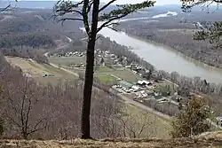 View of Wapwallopen | |
 Wapwallopen Location in Pennsylvania  Wapwallopen Location in the United States | |
| Coordinates: 41°04′28″N 76°7′51″W / 41.07444°N 76.13083°W | |
| Country | United States |
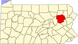
| State | Pennsylvania |
| County | Luzerne |
| Township | Conyngham |
| Elevation | 541 ft (165 m) |
| Time zone | Eastern (EST) |
| • Summer (DST) | EDT |
| ZIP code | 18660 |
| Area code | 570 |
| GNIS feature ID | 1193606[1] |
Wapwallopen is an unincorporated community in Conyngham Township, Luzerne County, Pennsylvania, United States.
It is named for a Lenni Lenape settlement that was established where Big Wapwallopen Creek feeds into the Susquehanna River. The name derives from Lenape òphalahpink 'place of white wild hemp'.[2][3][4]
Pennsylvania Route 239 passes through the settlement.
-
 Pennsylvania Route 239 in Wapwallopen
References
- ^ U.S. Geological Survey Geographic Names Information System: Wapwallopen
- ^ A History of the Wapwallopen Region. Wapwallopen Historical Society. 1964. p. 18. Retrieved June 3, 2019.
- ^ "òpi". Lenape Talking Dictionary. Retrieved June 3, 2019.
- ^ "halahpis". Lenape Talking Dictionary. Retrieved June 3, 2019.