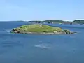
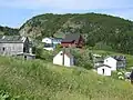
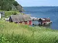
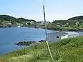
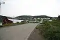
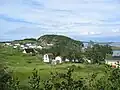
Tizzard's Harbour is a local service district and designated place in the Canadian province of Newfoundland and Labrador.
Geography
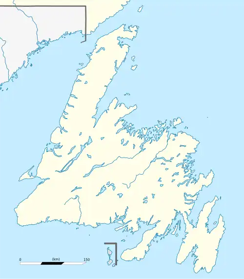
Tizzard's Harbour is in Newfoundland within Subdivision H of Division No. 8.[1]
Demographics
As a designated place in the 2016 Census of Population conducted by Statistics Canada, Tizzard's Harbour recorded a population of 55 living in 28 of its 62 total private dwellings, a change of 3.8% from its 2011 population of 53. With a land area of 1.83 km2 (0.71 sq mi), it had a population density of 30.1/km2 (77.8/sq mi) in 2016.[2]
Government
Tizzard's Harbour is a local service district (LSD)[3] that is governed by a committee responsible for the provision of certain services to the community.[4] The chair of the LSD committee is Rosemary Boyd.[3]
See also
References
- ^ "Population and dwelling counts, for Canada, provinces and territories, census divisions, census subdivisions (municipalities) and designated places, 2016 and 2011 censuses – 100% data (Newfoundland and Labrador)". Statistics Canada. February 7, 2018. Retrieved December 23, 2021.
- ^ "Population and dwelling counts, for Canada, provinces and territories, and designated places, 2016 and 2011 censuses – 100% data (Newfoundland and Labrador)". Statistics Canada. February 7, 2018. Retrieved December 22, 2021.
- ^ a b "Directory of Local Service Districts" (PDF). Government of Newfoundland and Labrador. October 2021. Retrieved January 1, 2022.
- ^ "Local Service Districts – Frequently Asked Questions". Government of Newfoundland and Labrador. Retrieved January 1, 2022.
|
|---|
| Towns | |
|---|
Unorganized
subdivisions | |
|---|
Designated
places | |
|---|
Dissolved
towns | |
|---|
|
|
|---|
|
Subdivisions and
statistical units | |
|---|
| Communities | |
|---|
| Cities | |
|---|
Local service
districts (LSDs)
and designated
places (DPLs) | Both LSDs
and DPLs |
- Aspen Cove
- Barachois Brook
- Bartlett's Harbour
- Bay St. George South
- Beaches
- Bear Cove, Northern Peninsula
- Beau Bois
- Bellevue
- Bellevue Beach
- Benoits Siding
- Benton
- Birchy Cove
- Black Duck
- Black Duck Brook and Winterhouse
- Black Duck Cove, Northern Peninsula
- Black Tickle
- Blaketown
- Boyd's Cove
- Bridgeport
- Brig Bay
- Brigus South
- Brown's Arm
- Buchans Junction
- Bunyan's Cove
- Burgoyne's Cove
- Burnside-St. Chads
- Burnt Cove, St. Michael's, Bauline South
- Burnt Point-Gull Island-Northern Bay
- Calvert
- Campbells Creek
- Canning's Cove
- Cape Freels North
- Cape Ray
- Caplin Cove-Southport
- Castor River North
- Castor River South
- Cavendish
- Chanceport
- Charlottetown, Bonavista Bay
- Cobb's Arm
- Cottrell's Cove
- Deadman's Bay
- Deep Bight
- Diamond Cove
- Dildo
- Dunfield
- Eddies Cove West
- Epworth-Great Salmonier
- Fairbanks-Hillgrade
- Fairhaven
- Flat Bay
- Forest Field-New Bridge
- Forresters Point
- Fox Island River-Point au Mal
- Fox Roost-Margaree
- Francois
- Freshwater, Conception Bay
- Gander Bay North
- Gander Bay South
- Garden Cove
- Georgetown
- Glovers Harbour
- Goobies
- Grates Cove
- Great Brehat
- Great Codroy
- Green Island Brook
- Green's Harbour
- Grey River
- Harbour Mille-Little Harbour East
- Harry's Harbour
- Herring Neck
- Hickman's Harbour-Robinson Bight
- Hodge's Cove
- Hopeall
- Horwood
- Indian Cove
- Jackson's Cove-Langdon's Cove-Silverdale
- Jean de Baie
- La Poile
- Lance Cove, Bell Island
- L'Anse aux Meadows to Quirpon
- Laurenceton
- Little Harbour (East), Placentia Bay
- Little Rapids
- Little St. Lawrence
- Lodge Bay
- Loon Bay
- Lower Lance Cove
- Main Point-Davidsville
- Mainland
- Makinsons
- Markland
- Marysvale
- Mattis Point
- McCallum
- Merritt's Harbour
- Mobile
- Moreton's Harbour
- Nameless Cove
- New Chelsea-New Melbourne-Brownsdale-Sibley's Cove-Lead Cove
- New Harbour, Trinity Bay
- Newman's Cove
- Newville
- Noggin Cove
- Norman's Bay
- Norris Arm North
- North Harbour, St. Mary's Bay
- O'Donnells
- Old Shop
- Open Hall-Red Cliffe
- O'Regan's Central
- Patrick's Cove-Angels Cove
- Pensons Arm
- Petit Forte
- Petley
- Phillips Head
- Piccadilly Head
- Piccadilly Slant-Abraham's Cove
- Pidgeon Cove-St. Barbe
- Pleasantview
- Plum Point
- Pollard's Point
- Port Albert
- Portland Creek
- Purcell's Harbour
- Pynns Brook
- Random Island West
- Random Sound West
- Rattling Brook
- Reefs Harbour-Shoal Cove West-New Ferolle
- Roaches Line
- Rock Harbour
- Searston
- Sheaves Cove
- Sheppardville
- Ship Cove, Northern Peninsula
- Ship Cove-Lower Cove-Jerry's Nose
- Smith's Harbour
- Smith's Sound
- Sop's Arm
- South Dildo
- South East Bight
- Spanish Room
- Spillars Cove
- St Andrews
- St. Anthony Bight
- St. Joseph's Cove-St. Veronica's
- St. Judes
- St Patricks
- St. Teresa
- Stanhope
- Stoneville
- Summerville-Princeton-Southern Bay
- Swift Current
- Thornlea
- Three Rock Cove
- Tompkins
- Tors Cove
- Upper Amherst Cove
- Upper Ferry
- Valley Pond
- Virgin Arm-Carter's Cove
- West Bay
- Wild Cove, White Bay
- William's Harbour
|
|---|
| LSDs only | |
|---|
| DPLs only | |
|---|
|
|---|
 Category:Newfoundland and Labrador Category:Newfoundland and Labrador Portal:Canada Portal:Canada WikiProject:Newfoundland and Labrador WikiProject:Newfoundland and Labrador
|
49°35′41″N 54°48′13″W / 49.59472°N 54.80361°W / 49.59472; -54.80361