Těchlovice (Hradec Králové District)
Těchlovice | |
|---|---|
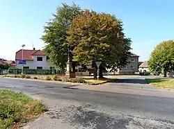 Centre of Těchlovice | |
 Flag  Coat of arms | |
 Těchlovice Location in the Czech Republic | |
| Coordinates: 50°12′27″N 15°42′40″E / 50.20750°N 15.71111°E | |
| Country | |
| Region | Hradec Králové |
| District | Hradec Králové |
| First mentioned | 1318 |
| Area | |
• Total | 3.30 km2 (1.27 sq mi) |
| Elevation | 245 m (804 ft) |
| Population (2025-01-01)[1] | |
• Total | 365 |
| • Density | 110/km2 (290/sq mi) |
| Time zone | UTC+1 (CET) |
| • Summer (DST) | UTC+2 (CEST) |
| Postal code | 503 27 |
| Website | www |
Těchlovice is a municipality and village in Hradec Králové District in the Hradec Králové Region of the Czech Republic. It has about 400 inhabitants.
Demographics
| Year | Pop. | ±% |
|---|---|---|
| 1869 | 561 | — |
| 1880 | 569 | +1.4% |
| 1890 | 548 | −3.7% |
| 1900 | 509 | −7.1% |
| 1910 | 505 | −0.8% |
| 1921 | 527 | +4.4% |
| 1930 | 505 | −4.2% |
| 1950 | 361 | −28.5% |
| 1961 | 368 | +1.9% |
| 1970 | 364 | −1.1% |
| 1980 | 333 | −8.5% |
| 1991 | 312 | −6.3% |
| 2001 | 311 | −0.3% |
| 2011 | 341 | +9.6% |
| 2021 | 363 | +6.5% |
| Source: Censuses[2][3] | ||
References
- ^ "Population of Municipalities – 1 January 2025". Czech Statistical Office. 2025-05-16.
- ^ "Historický lexikon obcí České republiky 1869–2011" (in Czech). Czech Statistical Office. 2015-12-21.
- ^ "Population Census 2021: Population by sex". Public Database. Czech Statistical Office. 2021-03-27.
External links
Wikimedia Commons has media related to Těchlovice (Hradec Králové District).