Synalov
Synalov | |
|---|---|
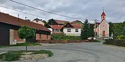 Centre of Synalov | |
 Flag  Coat of arms | |
 Synalov Location in the Czech Republic | |
| Coordinates: 49°25′58″N 16°24′50″E / 49.43278°N 16.41389°E | |
| Country | |
| Region | South Moravian |
| District | Brno-Country |
| First mentioned | 1360 |
| Area | |
• Total | 6.92 km2 (2.67 sq mi) |
| Elevation | 520 m (1,710 ft) |
| Population (2025-01-01)[1] | |
• Total | 118 |
| • Density | 17/km2 (44/sq mi) |
| Time zone | UTC+1 (CET) |
| • Summer (DST) | UTC+2 (CEST) |
| Postal code | 679 23 |
| Website | www |
Synalov is a municipality and village in Brno-Country District in the South Moravian Region of the Czech Republic. It has about 100 inhabitants.
Synalov lies approximately 31 kilometres (19 mi) north-west of Brno and 160 km (99 mi) south-east of Prague.
Demographics
| Year | Pop. | ±% |
|---|---|---|
| 1869 | 294 | — |
| 1880 | 311 | +5.8% |
| 1890 | 283 | −9.0% |
| 1900 | 325 | +14.8% |
| 1910 | 314 | −3.4% |
| 1921 | 316 | +0.6% |
| 1930 | 297 | −6.0% |
| 1950 | 240 | −19.2% |
| 1961 | 212 | −11.7% |
| 1970 | 183 | −13.7% |
| 1980 | 169 | −7.7% |
| 1991 | 130 | −23.1% |
| 2001 | 115 | −11.5% |
| 2011 | 120 | +4.3% |
| 2021 | 122 | +1.7% |
| Source: Censuses[2][3] | ||
References
- ^ "Population of Municipalities – 1 January 2025". Czech Statistical Office. 2025-05-16.
- ^ "Historický lexikon obcí České republiky 1869–2011" (in Czech). Czech Statistical Office. 2015-12-21.
- ^ "Population Census 2021: Population by sex". Public Database. Czech Statistical Office. 2021-03-27.
External links
Wikimedia Commons has media related to Synalov.