Moravské Bránice
Moravské Bránice | |
|---|---|
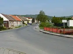 Entrance to Moravské Bránice | |
 Flag  Coat of arms | |
 Moravské Bránice Location in the Czech Republic | |
| Coordinates: 49°5′0″N 16°26′11″E / 49.08333°N 16.43639°E | |
| Country | |
| Region | South Moravian |
| District | Brno-Country |
| First mentioned | 1181 |
| Area | |
• Total | 8.21 km2 (3.17 sq mi) |
| Elevation | 205 m (673 ft) |
| Population (2025-01-01)[1] | |
• Total | 994 |
| • Density | 120/km2 (310/sq mi) |
| Time zone | UTC+1 (CET) |
| • Summer (DST) | UTC+2 (CEST) |
| Postal code | 664 64 |
| Website | www |
Moravské Bránice (German: Mährisch Branitz) is a municipality and village in Brno-Country District in the South Moravian Region of the Czech Republic. It has about 1,000 inhabitants.
Moravské Bránice lies on the Jihlava River, approximately 19 kilometres (12 mi) south-west of Brno and 183 km (114 mi) south-east of Prague.
Demographics
| Year | Pop. | ±% |
|---|---|---|
| 1869 | 592 | — |
| 1880 | 607 | +2.5% |
| 1890 | 609 | +0.3% |
| 1900 | 699 | +14.8% |
| 1910 | 767 | +9.7% |
| 1921 | 911 | +18.8% |
| 1930 | 1,078 | +18.3% |
| 1950 | 1,083 | +0.5% |
| 1961 | 1,159 | +7.0% |
| 1970 | 1,111 | −4.1% |
| 1980 | 938 | −15.6% |
| 1991 | 904 | −3.6% |
| 2001 | 913 | +1.0% |
| 2011 | 976 | +6.9% |
| 2021 | 952 | −2.5% |
| Source: Censuses[2][3] | ||
References
- ^ "Population of Municipalities – 1 January 2025". Czech Statistical Office. 2025-05-16.
- ^ "Historický lexikon obcí České republiky 1869–2011" (in Czech). Czech Statistical Office. 2015-12-21.
- ^ "Population Census 2021: Population by sex". Public Database. Czech Statistical Office. 2021-03-27.
External links
Wikimedia Commons has media related to Moravské Bránice.