Stavěšice
Stavěšice | |
|---|---|
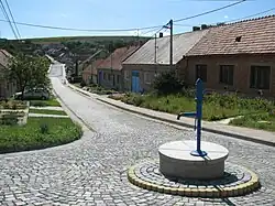 A street in Stavěšice | |
 Flag  Coat of arms | |
 Stavěšice Location in the Czech Republic | |
| Coordinates: 49°0′6″N 17°1′50″E / 49.00167°N 17.03056°E | |
| Country | |
| Region | South Moravian |
| District | Hodonín |
| First mentioned | 1389 |
| Area | |
• Total | 4.94 km2 (1.91 sq mi) |
| Elevation | 231 m (758 ft) |
| Population (2025-01-01)[1] | |
• Total | 374 |
| • Density | 76/km2 (200/sq mi) |
| Time zone | UTC+1 (CET) |
| • Summer (DST) | UTC+2 (CEST) |
| Postal code | 696 38 |
| Website | www |
Stavěšice is a municipality and village in Hodonín District in the South Moravian Region of the Czech Republic. It has about 400 inhabitants.
Stavěšice lies approximately 19 kilometres (12 mi) north-west of Hodonín, 38 km (24 mi) south-east of Brno, and 224 km (139 mi) south-east of Prague.
Demographics
| Year | Pop. | ±% |
|---|---|---|
| 1869 | 545 | — |
| 1880 | 597 | +9.5% |
| 1890 | 535 | −10.4% |
| 1900 | 646 | +20.7% |
| 1910 | 793 | +22.8% |
| 1921 | 770 | −2.9% |
| 1930 | 729 | −5.3% |
| 1950 | 595 | −18.4% |
| 1961 | 632 | +6.2% |
| 1970 | 596 | −5.7% |
| 1980 | 497 | −16.6% |
| 1991 | 364 | −26.8% |
| 2001 | 361 | −0.8% |
| 2011 | 330 | −8.6% |
| 2021 | 352 | +6.7% |
| Source: Censuses[2][3] | ||
References
- ^ "Population of Municipalities – 1 January 2025". Czech Statistical Office. 2025-05-16.
- ^ "Historický lexikon obcí České republiky 1869–2011" (in Czech). Czech Statistical Office. 2015-12-21.
- ^ "Population Census 2021: Population by sex". Public Database. Czech Statistical Office. 2021-03-27.
External links
Wikimedia Commons has media related to Stavěšice.