Skvrňov
Skvrňov | |
|---|---|
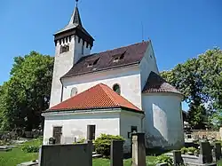 Church of Saint Gall | |
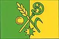 Flag  Coat of arms | |
 Skvrňov Location in the Czech Republic | |
| Coordinates: 49°53′50″N 15°0′7″E / 49.89722°N 15.00194°E | |
| Country | |
| Region | Central Bohemian |
| District | Kolín |
| First mentioned | 1295 |
| Area | |
• Total | 6.17 km2 (2.38 sq mi) |
| Elevation | 393 m (1,289 ft) |
| Population (2025-01-01)[1] | |
• Total | 226 |
| • Density | 37/km2 (95/sq mi) |
| Time zone | UTC+1 (CET) |
| • Summer (DST) | UTC+2 (CEST) |
| Postal code | 281 44 |
| Website | www |
Skvrňov is a municipality and village in Kolín District in the Central Bohemian Region of the Czech Republic. It has about 200 inhabitants.
Demographics
| Year | Pop. | ±% |
|---|---|---|
| 1869 | 494 | — |
| 1880 | 467 | −5.5% |
| 1890 | 500 | +7.1% |
| 1900 | 483 | −3.4% |
| 1910 | 453 | −6.2% |
| 1921 | 446 | −1.5% |
| 1930 | 403 | −9.6% |
| 1950 | 320 | −20.6% |
| 1961 | 314 | −1.9% |
| 1970 | 257 | −18.2% |
| 1980 | 251 | −2.3% |
| 1991 | 212 | −15.5% |
| 2001 | 166 | −21.7% |
| 2011 | 181 | +9.0% |
| 2021 | 219 | +21.0% |
| Source: Censuses[2][3] | ||
References
- ^ "Population of Municipalities – 1 January 2025". Czech Statistical Office. 2025-05-16.
- ^ "Historický lexikon obcí České republiky 1869–2011" (in Czech). Czech Statistical Office. 2015-12-21.
- ^ "Population Census 2021: Population by sex". Public Database. Czech Statistical Office. 2021-03-27.
External links
Wikimedia Commons has media related to Skvrňov.