Savigny, Manche
Savigny | |
|---|---|
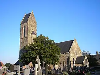 The church of Notre-Dame | |
 Coat of arms | |
Location of Savigny | |
 Savigny  Savigny | |
| Coordinates: 49°03′02″N 1°20′15″W / 49.0506°N 1.3375°W | |
| Country | France |
| Region | Normandy |
| Department | Manche |
| Arrondissement | Coutances |
| Canton | Quettreville-sur-Sienne |
| Intercommunality | Coutances Mer et Bocage |
| Government | |
| • Mayor (2020–2026) | Vincent Leclerc[1] |
Area 1 | 10.16 km2 (3.92 sq mi) |
| Population (2022)[2] | 433 |
| • Density | 43/km2 (110/sq mi) |
| Time zone | UTC+01:00 (CET) |
| • Summer (DST) | UTC+02:00 (CEST) |
| INSEE/Postal code | 50569 /50210 |
| Elevation | 35–135 m (115–443 ft) (avg. 130 m or 430 ft) |
| 1 French Land Register data, which excludes lakes, ponds, glaciers > 1 km2 (0.386 sq mi or 247 acres) and river estuaries. | |

Savigny (French pronunciation: [saviɲi] ⓘ) is a commune in the Manche department in Normandy in north-western France. Its historic sites include the church of Notre-Dame-et-Sainte-Barbe which has an early 12th-century Romanesque apse and 14th-century murals portraying the martyrdom of Saint Barbara.[3] Wikimedia Commons featured an image of the interior as its "Picture of the Day" for December 4, 2024.[4]
See also
References
- ^ "Répertoire national des élus: les maires". data.gouv.fr, Plateforme ouverte des données publiques françaises (in French). 2 December 2020.
- ^ "Populations de référence 2022" (in French). The National Institute of Statistics and Economic Studies. 19 December 2024.
- ^ Pérouse de Montclos, Jean-Marie, ed. (2013). Le patrimoine en Normandie. Paris: Éd. Place des Victoires. pp. 420–21. ISBN 978-2-8099-1056-8.
- ^ "Wikimedia Commons". commons.wikimedia.org. Retrieved 4 December 2024.
Wikimedia Commons has media related to Savigny (Manche).