Saint-Coutant, Deux-Sèvres
Saint-Coutant | |
|---|---|
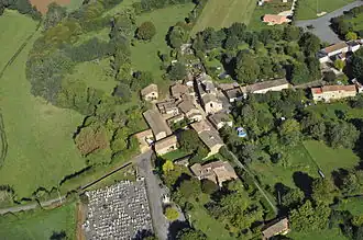 Aerial view of the church and village | |
Location of Saint-Coutant | |
 Saint-Coutant  Saint-Coutant | |
| Coordinates: 46°13′48″N 0°00′41″W / 46.23°N 0.0114°W | |
| Country | France |
| Region | Nouvelle-Aquitaine |
| Department | Deux-Sèvres |
| Arrondissement | Niort |
| Canton | Celles-sur-Belle |
| Government | |
| • Mayor (2020–2026) | Odile Thellier[1] |
Area 1 | 11.94 km2 (4.61 sq mi) |
| Population (2022)[2] | 277 |
| • Density | 23/km2 (60/sq mi) |
| Time zone | UTC+01:00 (CET) |
| • Summer (DST) | UTC+02:00 (CEST) |
| INSEE/Postal code | 79243 /79120 |
| Elevation | 124–164 m (407–538 ft) (avg. 286 m or 938 ft) |
| 1 French Land Register data, which excludes lakes, ponds, glaciers > 1 km2 (0.386 sq mi or 247 acres) and river estuaries. | |
Saint-Coutant (French pronunciation: [sɛ̃ kutɑ̃]) is a commune in the Deux-Sèvres department in western France.
See also
References
- ^ "Répertoire national des élus: les maires". data.gouv.fr, Plateforme ouverte des données publiques françaises (in French). 2 December 2020.
- ^ "Populations de référence 2022" (in French). The National Institute of Statistics and Economic Studies. 19 December 2024.
Bibliography
- Maurice Poignat, Le Pays mellois (Poitiers: Projet Editions, 1982. ISBN 2-905282-15-0) pp. 264–267
External links
Wikimedia Commons has media related to Saint-Coutant (Deux-Sèvres).