Rambergssjøen
| Rambergssjøen | |
|---|---|
 | |
Interactive map of the lake | |
| Location | Røros Municipality, Trøndelag |
| Coordinates | 62°29′47″N 11°35′17″E / 62.4964°N 11.5880°E / 62.4964; 11.5880 |
| Primary inflows | Håsjøen |
| Primary outflows | Håelva river |
| Catchment area | Glommadal |
| Basin countries | Norway |
| Max. length | 5.5 kilometres (3.4 mi) |
| Max. width | 1 kilometre (0.62 mi) |
| Surface area | 3.1 km2 (1.2 sq mi) |
| Shore length1 | 18.58 kilometres (11.55 mi) |
| Surface elevation | 646 metres (2,119 ft) |
| References | NVE[1] |
| 1 Shore length is not a well-defined measure. | |
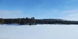
Rambergssjøen[2] is a lake in Røros Municipality in Trøndelag county, Norway. The lake is located along the river Håelva, just downstream from the lake Håsjøen. The 3.1-square-kilometre (1.2 sq mi) lake is located about 12 kilometres (7.5 mi) southeast of the town of Røros.[3]
See also
References
- ^ "Innsjødatabase". NVE.no (in Norwegian). Retrieved 2024-12-30.
- ^ "Informasjon om stadnamn". Norgeskart (in Norwegian). Kartverket. Retrieved 2024-12-30.
- ^ "Rambergssjøen, Røros (Trøndelag)" (in Norwegian). yr.no. Retrieved 2024-12-30.
This article is issued from Wikipedia. The text is available under Creative Commons Attribution-Share Alike 4.0 unless otherwise noted. Additional terms may apply for the media files.