Orobó
Orobó | |
|---|---|
 Parish of Our Lady of Conception church | |
 Flag  Coat of arms | |
| Etymology: Named after the Orobó stream[1] | |
| Motto(s): | |
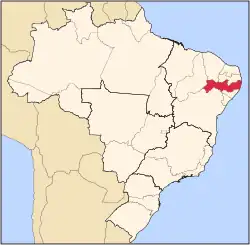
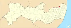 Location of Orobó in Pernambuco | |
 Orobó  Orobó | |
| Coordinates: 7°44′42″S 35°36′7″W / 7.74500°S 35.60194°W | |
| Country | |
| Region | Northeast |
| State | |
| Founded | 11 September 1928[1] |
| Government | |
| • Mayor | Severino Luiz Pereira de Abreu (PSDB) (2025-2028)[4][5] |
| • Vice Mayor | Lia Mãe de Chaparral (UNIÃO) (2025-2028)[4][5] |
| Area | |
• Total | 138.362 km2 (53.422 sq mi) |
| Elevation | 415 m (1,362 ft) |
| Population (2022) | |
• Total | 21,808[3] |
| • Density | 157.43/km2 (407.7/sq mi) |
| Demonym | Orobense (Brazilian Portuguese)[3] |
| Time zone | UTC-03:00 (Brasília Time) |
| Postal code | 55745-000, 55746-000, 55747-000, 55748-000[6] |
| HDI (2010) | 0.610 – medium[3] |
| Website | orobo.pe.gov.br |
Orobó is a municipality/city in the state of Pernambuco in Brazil. The population in 2020 was 23,935 inhabitants and the total area is 138.66 km2.[7] The city has the lowest children's mortality rate of the state (2.9) and one of the lowest in the whole country.
Geography
- State - Pernambuco
- Region - Agreste of Pernambuco
- Boundaries - Paraíba state (N); Bom Jardim (S); Machados and São Vicente Ferrer (E); Casinhas (W).
- Area - 140.78 km2
- Elevation - 415 m
- Hydrography - Goiana River
- Vegetation - Caducifólia and Subcaducifólia forests
- Climate - Tropical hot and humid
- Annual average temperature - 25.0 c
- Distance to Recife - 127.4 km
Economy
The main economic activities in Orobó are related with commerce and agribusiness, especially creations of cattle, goats, pigs, chickens; and plantations of bananas and sugarcane.
Economic Indicators
| Population [8] | GDP x(1000 R$).[9] | GDP pc (R$) | PE |
|---|---|---|---|
| 22.239 | 72.461 | 3.350 | 0.12% |
Economy by Sector 2006
| Primary sector | Secondary sector | Service sector |
|---|---|---|
| 20.17% | 6.74% | 73.09% |
Health Indicators
| HDI (2000) | Hospitals (2007) | Hospitals beds (2007) | Children's Mortality every 1000 (2005) |
|---|---|---|---|
| 0.612 | 1 | 29 | 2.9 |
See also
References
- ^ a b "História & Fotos". Instituto Brasileiro de Geografia e Estatística (in Brazilian Portuguese). Instituto Brasileiro de Geografia e Estatística. Retrieved 26 February 2025.
- ^ "Plano Municipal de Educação" (PDF). Município de Orobó (in Brazilian Portuguese). Município de Orobó. Retrieved 26 February 2025.
- ^ a b c "Orobó". Instituto Brasileiro de Geografia e Estatística (in Brazilian Portuguese). Instituto Brasileiro de Geografia e Estatística. Retrieved 26 February 2025.
- ^ a b "Eleições 2024: Biu Abreu (PSDB) | Candidato(a) a prefeito(a) de Orobó-PE". Folha de S.Paulo (in Brazilian Portuguese). Folha de S.Paulo. 30 November 2024. Retrieved 26 February 2025.
- ^ a b "Prefeito de Orobó (PE) toma posse nesta quarta (1º); veja lista de vereadores eleitos". G1 (in Brazilian Portuguese). Globo. 31 December 2024. Retrieved 26 February 2025.
- ^ "CEP Orobó/PE - Brasil". codigo-postal.org (in Brazilian Portuguese). codigo-postal.org. Retrieved 26 February 2025.
- ^ IBGE 2020
- ^ Population 2009 Orobó, page 33, IBGE
- ^ Orobó 2007 GDP IBGE page 31 Archived 4 March 2016 at the Wayback Machine
- ^ PE State site - City by city profile Archived 4 August 2009 at the Wayback Machine
Capital: Recife | ||||||||||||||
| Mesoregion Agreste Pernambucano |
|  | ||||||||||||
| Mesoregion Mata Pernambucana |
| |||||||||||||
| Mesoregion Metropolitana de Recife |
| |||||||||||||
| Mesoregion Sao Francisco Pernambucano |
| |||||||||||||
| Mesoregion Sertão Pernambucano |
| |||||||||||||