Notre-Dame-des-Neiges
Notre-Dame-des-Neiges | |
|---|---|
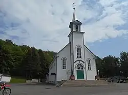 Saint-Jean-Baptiste Church | |
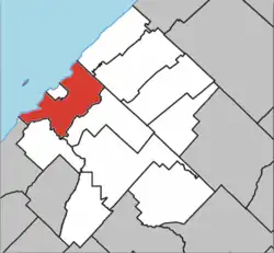 Location within Les Basques RCM | |
 Notre-Dame-des-Neiges Location in eastern Quebec | |
| Coordinates: 48°05′52″N 69°12′42″W / 48.0978°N 69.2117°W[1] | |
| Country | |
| Province | |
| Region | Bas-Saint-Laurent |
| RCM | Les Basques |
| Constituted | July 1, 1855 |
| Government | |
| • Mayor | Jean-Marie Dugas |
| • Federal riding | Rimouski—La Matapédia |
| • Prov. riding | Rivière-du-Loup–Témiscouata |
| Area | |
• Total | 93.50 km2 (36.10 sq mi) |
| • Land | 94.44 km2 (36.46 sq mi) |
| There is an apparent contradiction between two authoritative sources | |
| Population | |
• Total | 1,194 |
| • Density | 12.6/km2 (33/sq mi) |
| • Pop 2016-2021 | |
| • Dwellings | 815 |
| Time zone | UTC−5 (EST) |
| • Summer (DST) | UTC−4 (EDT) |
| Postal code(s) | |
| Area codes | 418 and 581 |
| Highways | |
| Website | www.notredame desneiges.qc.ca |
Notre-Dame-des-Neiges (French pronunciation: [nɔtʁə dam de nɛʒ]) is a municipality in Quebec, Canada. It encircles the city of Trois-Pistoles and includes the offshore Île aux Basques.
Geography
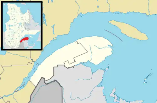
Notre-Dame-des-Neiges is located on the southern shore of the St. Lawrence River, 250 km northeast of Quebec City. Important towns near Notre-Dame-des-Neiges are Rivière-du-Loup 45 km to the south-west and Rimouski 60 km to the northeast. Notre-Dame-des-Neiges is located on Route 293 which connects Trois-Pistoles to Route 232 between Trois-Pistoles to the northwest and Saint-Jean-de-Dieu to the southeast. The territory of Notre-Dame-des-Neiges covers an area of 94.44 km2.
The territory of the municipality of Notre-Dame-des-Neiges partially overlooks the St. Lawrence River and almost completely enclaves the city of Trois-Pistoles. It is part of the regional county municipality of Les Basques in the administrative region of Bas-Saint-Laurent and is crossed by the Trois Pistoles river.[1]
Demographics
Population
| 2021 | 2016 | 2011 | |
|---|---|---|---|
| Population | 1,194 (10.0% from 2016) | 1,085 (-3.9% from 2011) | 1,129 (-6.6% from 2006) |
| Land area | 94.44 km2 (36.46 sq mi) | 94.21 km2 (36.37 sq mi) | 94.22 km2 (36.38 sq mi) |
| Population density | 12.6/km2 (33/sq mi) | 11.5/km2 (30/sq mi) | 12.0/km2 (31/sq mi) |
| Median age | 57.2 (M: 57.2, F: 58.0) | 56.9 (M: 56.9, F: 56.9) | 53.4 (M: 53.5, F: 53.3) |
| Private dwellings | 815 (total) | 778 (total) | 789 (total) |
| Median household income | $62,000 | $54,848 | $51,684 |
| Year | Pop. | ±% |
|---|---|---|
| 1861 | 3,451 | — |
| 1871 | 3,967 | +15.0% |
| 1881 | 2,872 | −27.6% |
| 1891 | 2,495 | −13.1% |
| 1901 | 2,595 | +4.0% |
| 1911 | 3,076 | +18.5% |
| 1921 | 1,801 | −41.4% |
| 1931 | 1,645 | −8.7% |
| 1941 | 1,611 | −2.1% |
| 1951 | 1,659 | +3.0% |
| 1956 | 1,641 | −1.1% |
| 1961 | 1,702 | +3.7% |
| 1966 | 1,363 | −19.9% |
| 1971 | 1,206 | −11.5% |
| 1976 | 1,140 | −5.5% |
| 1981 | 1,206 | +5.8% |
| 1986 | 1,233 | +2.2% |
| 1991 | 1,177 | −4.5% |
| 1996 | 1,318 | +12.0% |
| 2001 | 1,294 | −1.8% |
| 2006 | 1,209 | −6.6% |
| 2011 | 1,129 | −6.6% |
| 2016 | 1,085 | −3.9% |
| 2021 | 1,194 | +10.0% |
Language
| Canada Census Mother Tongue - Notre-Dame-des-Neiges, Quebec[7] | ||||||||||||||||||
|---|---|---|---|---|---|---|---|---|---|---|---|---|---|---|---|---|---|---|
| Census | Total | French
|
English
|
French & English
|
Other
| |||||||||||||
| Year | Responses | Count | Trend | Pop % | Count | Trend | Pop % | Count | Trend | Pop % | Count | Trend | Pop % | |||||
2021
|
1,195
|
1,180 | 98.7% | 5 | 0.4% | 5 | 0.4% | 0 | 0.0% | |||||||||
2016
|
1,085
|
1,080 | 99.5% | 5 | 0.5% | 0 | 0.0% | 0 | 0.0% | |||||||||
2011
|
1,130
|
1,125 | 99.6% | 5 | 0.4% | 0 | 0.0% | 0 | 0.0% | |||||||||
2006
|
1,205
|
1,185 | 98.3% | 10 | 0.8% | 0 | 0.0% | 10 | 0.8% | |||||||||
2001
|
1,295
|
1,295 | 100.0% | 0 | 0.0% | 0 | 0.0% | 0 | 0.0% | |||||||||
1996
|
1,320
|
1,310 | n/a | 99.2% | 10 | n/a | 0.8% | 0 | n/a | 0.0% | 0 | n/a | 0.0% | |||||
See also
References
- ^ a b "Banque de noms de lieux du Québec: Reference number 333975". toponymie.gouv.qc.ca (in French). Commission de toponymie du Québec.
- ^ a b "Répertoire des municipalités: Geographic code 11045". www.mamh.gouv.qc.ca (in French). Ministère des Affaires municipales et de l'Habitation.
- ^ a b "Data table, Census Profile, 2021 Census of Population - Notre-Dame-des-Neiges, Municipalité (MÉ) [Census subdivision], Quebec". 9 February 2022.
- ^ "2021 Community Profiles". 2021 Canadian census. Statistics Canada. February 4, 2022. Retrieved 2022-08-23.
- ^ "2016 Community Profiles". 2016 Canadian census. Statistics Canada. August 12, 2021. Retrieved 2022-07-07.
- ^ "2011 Community Profiles". 2011 Canadian census. Statistics Canada. March 21, 2019.
- ^ a b Statistics Canada: 1996, 2001, 2006, 2011, 2016, 2021 census
External links
![]() Media related to Notre-Dame-des-Neiges, Quebec at Wikimedia Commons
Media related to Notre-Dame-des-Neiges, Quebec at Wikimedia Commons
Adjacent municipal subdivisions | |
|---|---|
| Cities & towns | |
|---|---|
| Municipalities | |
| Parishes | |
| Unorganized territories | |
| |