Saint-Médard, Quebec
Saint-Médard | |
|---|---|
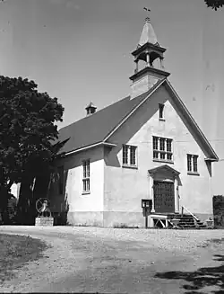 Church Saint-Médard | |
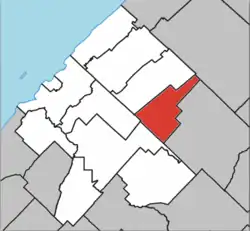 Location within Les Basques RCM | |
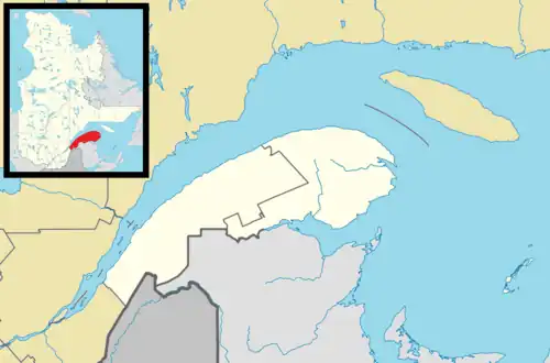 Saint-Médard Location in eastern Quebec | |
| Coordinates: 48°02′N 68°54′W / 48.033°N 68.900°W[1] | |
| Country | |
| Province | |
| Region | Bas-Saint-Laurent |
| RCM | Les Basques |
| Constituted | January 1, 1949 |
| Government | |
| • Mayor | Linda Gagnon |
| • Federal riding | Rimouski—La Matapédia |
| • Prov. riding | Rivière-du-Loup–Témiscouata |
| Area | |
• Total | 74.80 km2 (28.88 sq mi) |
| • Land | 75.28 km2 (29.07 sq mi) |
| There is an apparent contradiction between two authoritative sources | |
| Population | |
• Total | 216 |
| • Density | 2.9/km2 (8/sq mi) |
| • Pop 2016-2011 | |
| • Dwellings | 120 |
| Time zone | UTC−5 (EST) |
| • Summer (DST) | UTC−4 (EDT) |
| Postal code(s) | |
| Area codes | 418 and 581 |
| Highways | |
| Website | www.info-basques.com/ stmedard/index.htm |
Saint-Médard (French pronunciation: [sɛ̃ medaʁ]) is a municipality in Quebec, Canada.
Demographics
Population
Canada census – Saint-Médard community profile
| 2021 | 2016 | 2011 | |
|---|---|---|---|
| Population | 216 (+3.3% from 2016) | 209 (-5.9% from 2011) | 222 (-11.9% from 2006) |
| Land area | 75.28 km2 (29.07 sq mi) | 75.28 km2 (29.07 sq mi) | 75.88 km2 (29.30 sq mi) |
| Population density | 2.9/km2 (7.5/sq mi) | 2.8/km2 (7.3/sq mi) | 2.9/km2 (7.5/sq mi) |
| Median age | 56 (M: 56, F: 56) | 57.3 (M: 56.5, F: 58.0) | 52.3 (M: 50.8, F: 53.0) |
| Private dwellings | 120 (total) | 115 (total) | 116 (total) |
| Median household income | $n/a | $32,448 | $45,798 |
| Year | Pop. | ±% |
|---|---|---|
| 1951 | 606 | — |
| 1956 | 637 | +5.1% |
| 1961 | 661 | +3.8% |
| 1966 | 589 | −10.9% |
| 1971 | 478 | −18.8% |
| 1976 | 398 | −16.7% |
| 1981 | 404 | +1.5% |
| 1986 | 374 | −7.4% |
| 1991 | 321 | −14.2% |
| 1996 | 314 | −2.2% |
| 2001 | 281 | −10.5% |
| 2006 | 252 | −10.3% |
| 2011 | 222 | −11.9% |
| 2016 | 209 | −5.9% |
| 2021 | 216 | +3.3% |
Language
| Canada Census Mother Tongue - Saint-Médard, Quebec[7] | ||||||||||||||||||
|---|---|---|---|---|---|---|---|---|---|---|---|---|---|---|---|---|---|---|
| Census | Total | French
|
English
|
French & English
|
Other
| |||||||||||||
| Year | Responses | Count | Trend | Pop % | Count | Trend | Pop % | Count | Trend | Pop % | Count | Trend | Pop % | |||||
2021
|
215
|
210 | 97.7% | 5 | 2.3% | 0 | 0.0% | 0 | 0.0% | |||||||||
2016
|
210
|
210 | 100.0% | 0 | 0.0% | 0 | 0.0% | 0 | 0.0% | |||||||||
2011
|
225
|
220 | 97.8% | 5 | 2.2% | 0 | 0.0% | 0 | 0.0% | |||||||||
2006
|
250
|
250 | 100.0% | 0 | 0.0% | 0 | 0.0% | 0 | 0.0% | |||||||||
2001
|
285
|
285 | 100.0% | 0 | 0.0% | 0 | 0.0% | 0 | 0.0% | |||||||||
1996
|
315
|
315 | n/a | 100.0% | 0 | n/a | 0.0% | 0 | n/a | 0.0% | 0 | n/a | 0.0% | |||||
See also
References
- ^ "Banque de noms de lieux du Québec: Reference number 57233". toponymie.gouv.qc.ca (in French). Commission de toponymie du Québec.
- ^ a b "Répertoire des municipalités: Geographic code 11025". www.mamh.gouv.qc.ca (in French). Ministère des Affaires municipales et de l'Habitation.
- ^ a b https://www12.statcan.gc.ca/census-recensement/2021/dp-pd/prof/details/page.cfm?LANG=E&GENDERlist=1&STATISTIClist=1,4&DGUIDlist=2021A00052411025&HEADERlist=0&SearchText=Saint-M?dard
- ^ "2021 Community Profiles". 2021 Canadian census. Statistics Canada. February 4, 2022. Retrieved 2022-04-27.
- ^ "2016 Community Profiles". 2016 Canadian census. Statistics Canada. August 12, 2021. Retrieved 2024-10-04.
- ^ "2011 Community Profiles". 2011 Canadian census. Statistics Canada. March 21, 2019. Retrieved 2014-03-10.
- ^ a b Statistics Canada: 1996, 2001, 2006, 2011, 2016, 2021 census
Adjacent Municipal Subdivisions | |
|---|---|
| Cities & towns | |
|---|---|
| Municipalities | |
| Parishes | |
| Unorganized territories | |
| |