Monchy-sur-Eu
Monchy-sur-Eu | |
|---|---|
_France_(3).JPG) The town hall and school in Monchy-sur-Eu | |
 Coat of arms | |
Location of Monchy-sur-Eu | |
 Monchy-sur-Eu  Monchy-sur-Eu | |
| Coordinates: 49°59′45″N 1°27′14″E / 49.9958°N 1.4539°E | |
| Country | France |
| Region | Normandy |
| Department | Seine-Maritime |
| Arrondissement | Dieppe |
| Canton | Eu |
| Intercommunality | CC Villes Sœurs |
| Government | |
| • Mayor (2020–2026) | Christian Coulombel[1] |
Area 1 | 8.99 km2 (3.47 sq mi) |
| Population (2022)[2] | 554 |
| • Density | 62/km2 (160/sq mi) |
| Time zone | UTC+01:00 (CET) |
| • Summer (DST) | UTC+02:00 (CEST) |
| INSEE/Postal code | 76442 /76260 |
| Elevation | 49–142 m (161–466 ft) (avg. 119 m or 390 ft) |
| 1 French Land Register data, which excludes lakes, ponds, glaciers > 1 km2 (0.386 sq mi or 247 acres) and river estuaries. | |
Monchy-sur-Eu is a commune in the Seine-Maritime department in the Normandy region in northern France.
Geography
A forestry and farming village situated in the Pays de Bray, some 20 miles (32 km) northeast of Dieppe at the junction of the D126 and the D58 roads.
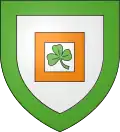
Heraldry
|
The arms of Monchy-sur-Eu are blazoned : Argent, within a square voided tenné, a trefoil, all within a bordure vert. (tenné may not be a 'proper' tincture but it's the closest that English heraldry has to orange.)
|
Population
| Year | Pop. | ±% p.a. |
|---|---|---|
| 1968 | 431 | — |
| 1975 | 398 | −1.13% |
| 1982 | 431 | +1.14% |
| 1990 | 478 | +1.30% |
| 1999 | 492 | +0.32% |
| 2007 | 544 | +1.26% |
| 2012 | 584 | +1.43% |
| 2017 | 587 | +0.10% |
| Source: INSEE[3] | ||
Places of interest
- The church of St. Riquier, dating from the seventeenth century.
See also
References
- ^ Liste des maires du département de la Seine-Maritime, 10 August 2020
- ^ "Populations de référence 2022" (in French). The National Institute of Statistics and Economic Studies. 19 December 2024.
- ^ Population en historique depuis 1968, INSEE
Wikimedia Commons has media related to Monchy-sur-Eu.