Municipality of the District of Argyle
Argyle | |
|---|---|
| Municipality of the District of Argyle Municipalité du district d'Argyle | |
 Flag  Seal | |
| Motto: Industry | |
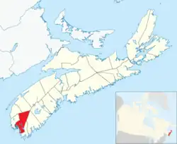 Location of the Municipality of the District of Argyle | |
| Coordinates: 43°48′N 65°51′W / 43.8°N 65.85°W | |
| Country | Canada |
| Province | Nova Scotia |
| County | Yarmouth |
| Incorporated | April 17, 1879 |
| Electoral Districts Federal | Acadie—Annapolis |
| Provincial | Argyle |
| Government | |
| • Type | Argyle Municipal Council |
| • Municipal Seat | Tusket |
| • Warden | Nicole Albright |
| • Deputy Warden | Ted Saulnier |
| • Councillors | List of Members
|
| Area | |
| • Land | 1,528.17 km2 (590.03 sq mi) |
| Population | |
• Total | 7,899 |
| • Density | 5.2/km2 (13/sq mi) |
| • Change 2011-16 | |
| Time zone | UTC-4 (AST) |
| • Summer (DST) | UTC-3 (ADT) |
| Area code | 902 |
| Dwellings | 3,821 |
| Median Income* | $49,898 CDN |
| Website | www |
| *Median household income, 2005 (all households) | |
Argyle, officially named the Municipality of the District of Argyle, is a district municipality in Yarmouth County, Nova Scotia. Statistics Canada classifies the district municipality as a municipal district.
The district municipality occupies the eastern portion of the county and is one of three municipal units - the other two being the Town of Yarmouth and the Municipality of the District of Yarmouth. Argyle is a bilingual community, in which native speakers of English and French each account for about half of the population. As of 2016, 60% of the population speaks both French and English, one of the highest rates of bilingualism in Canada.[3]
History
Originally inhabited by the Mi'kmaq, it was called "Bapkoktek".[4] In 1766, after his service in the French and Indian Wars, Lt. Ranald MacKinnon was given a land grant of 2,000 acres (8.1 km2). He called it Argyle (Argyll) because he was reminded of his previous home in the Highlands of Scotland.[4] The township was granted in 1771.[4]
Demographics
In the 2021 Census of Population conducted by Statistics Canada, the Municipality of the District of Argyle had a population of 7,870 living in 3,455 of its 3,818 total private dwellings, a change of -0.4% from its 2016 population of 7,899. With a land area of 1,526.07 km2 (589.22 sq mi), it had a population density of 5.2/km2 (13.4/sq mi) in 2021.[7] In the 2021 Canadian census conducted by Statistics Canada, the Municipality of the District of Yarmouth had a population of 10,067 living in 4,430 of its 5,072 total private dwellings, a change of 2.3% from its 2016 population of 9,845. With a land area of 584.69 km2 (225.75 sq mi), it had a population density of 17.2/km2 (44.6/sq mi) in 2021.[8]
|
|
Communities
- Amiraults Hill
- Argyle
- Argyle Sound
- Central Argyle
- Comeau's Hill
- East Kemptville
- East Pubnico
- East Quinan
- Glenwood
- Hubbard's Point
- Lower Argyle
- Lower East Pubnico
- Lower Eel Brook
- Lower Wedgeport
- Lower West Pubnico
- Middle East Pubnico
- Middle West Pubnico
- Morris Island
- North Belleville
- Plymouth
- Pubnico
- Quinan
- Sluice Point
- South Belleville
- Ste. Anne du Ruisseau
- Surette's Island
- Tusket
- Tusket Falls
- Tusket Islands
- Upper Wedgeport
- Wedgeport
- West Pubnico
See also
- List of francophone communities in Nova Scotia
- List of municipalities in Nova Scotia
Notes
- ^ a b Top ten responses
- ^ There were 65 French Canadians or 0.6% of the population
References
- ^ a b Statistics Canada. "Population and dwelling counts, for Canada, provinces and territories, and census subdivisions (municipalities), 2011 and 2006 censuses". Retrieved 2015-06-21.
- ^ Statistics Canada Population and dwelling counts, for Canada and census subdivisions (municipalities), 2016 censuses - 100% data
- ^ Western Regional Enterprise Network
- ^ a b c Brown, Thomas J. (1922). Place-names of the Province of Nova Scotia. Halifax, Nova Scotia: Royal Print & Litho. p. 11.
- ^ 1996, 2001, 2006 census
- ^ Town of Yarmouth (January 10, 2008). Municipal Planning Strategy (Report). Town of Yarmouth. p. 7.
- ^ a b "Population and dwelling counts: Canada, provinces and territories, census divisions and census subdivisions (municipalities), Nova Scotia". Statistics Canada. February 9, 2022. Retrieved March 12, 2022.
- ^ a b c d e f "Census Profile, 2021 Census of Population Profile table Yarmouth, Municipal district (MD) Nova Scotia [Census subdivision]". Statistics Canada. February 1, 2023. Retrieved August 12, 2023.
External links
Places adjacent to Municipality of the District of Argyle | |
|---|---|
Subdivisions of Nova Scotia | |||||||
|---|---|---|---|---|---|---|---|
| Counties | |||||||
| Municipalities |
| ||||||
| Towns | |||||||
| Villages | |||||||
| Economic regions | |||||||
| Lists | |||||||
| |||||||