Logone Oriental (prefecture)
| Logone Oriental Prefecture Préfecture du Logone Oriental | |||||||||||
|---|---|---|---|---|---|---|---|---|---|---|---|
| Prefecture of Chad | |||||||||||
| 1962–1999 | |||||||||||
 | |||||||||||
 | |||||||||||
| Capital | Doba | ||||||||||
| Area | |||||||||||
| • Coordinates | 8°39′N 16°51′E / 8.650°N 16.850°E | ||||||||||
• 1993 | 28,035 km2 (10,824 sq mi) | ||||||||||
| Population | |||||||||||
• 1993 | 441,064 | ||||||||||
| • Type | Prefecture | ||||||||||
| Historical era | Cold War | ||||||||||
• Established[1] | 9 January 1962 | ||||||||||
• Disestablished[1] | 1 September 1999 | ||||||||||
| Political subdivisions | Sub-prefectures (1993)[2]
| ||||||||||
| |||||||||||
| Area and population source:[1] | |||||||||||
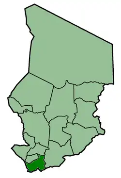
Logone Oriental was one of the 14 prefectures of Chad. Located in the southwest of the country, Logone Oriental covered an area of 28,035 square kilometers and had a population of 441,064 in 1993. Its capital was Doba.
See also
References
- ^ a b c "Administrative Divisions of Countries: Regions of Chad". www.statoids.com.
- ^ "Administrative Divisions of Countries: Departments of Chad". www.statoids.com.
| |||
|
Batha · Biltine · Borkou-Ennedi-Tibesti · Chari-Baguirmi · Guéra · Kanem · Lac · Logone Occidental · Logone Oriental · Mayo-Kébbi · Moyen-Chari · Ouaddaï · Salamat · Tandjilé · | |||
|
See also : Regions of Chad - Departments of Chad |