Jequitinhonha
Jequitinhonha | |
|---|---|
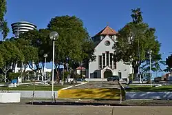 Church of St. Michael and Souls in Jequitinhonha | |
 | |
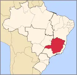
| Country | Brazil |
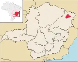
| State | Minas Gerais |
| Intermediate Geographic Region | Teófilo Otoni |
| Immediate Geographic Region | Almenara |
| Incorporated | 30 August 1911 |
| Government | |
| • Mayor | Nilo Barbuda Souto (PDT) |
| Area | |
• Total | 3 514 km2 (1,356 sq mi) |
| Population (2020) | |
• Total | 25,474[1] |
| • Density | 7.3/km2 (19/sq mi) |
| Demonym | Jequitinhonhense |
| Time zone | UTC−3 (BRT) |
| Postal Code | 39960-000 |
| Area code(s) | +55 33 |
| Website | jequitinhonha.mg.gov.br |
Jequitinhonha (Brazilian Portuguese: [ʒekitʃiˈɲõɲɐ]) is a Brazilian municipality located in the northeast of the state of Minas Gerais.
Geography
The population as of 2020 was estimated to be 25,474 people living in a total area of 3,518 km².[2] The city belongs to the mesoregion of Jequitinhonha and to the microregion of Almenara.[3]
Jequitinhonha is located on the river of the same name. The elevation is 223 meters. It became a municipality in 1911. The distance to the state capital, Belo Horizonte is 582 km.
Neighboring municipalities are: Joaíma, Felisburgo, Rubim, Almenara and Pedra Azul.
The municipality contains most of the 50,890 hectares (125,800 acres) Mata Escura Biological Reserve, created in 2003.[4]
Economy
The main economic activities are cattle raising and the cultivation of coffee, sugarcane and corn. The GDP in 2006 was R$66,471,000. There were 02 banking agencies as of 2007. In the same year there were 699 automobiles, which was a ratio of one automobile for every 30 people. In the rural area there were 1,905 producers of which only 51 had tractors. There were 88,000 head of cattle in 2006.[5] This municipality is isolated from major population centers and suffers from drought and poor soils.
Social indicators
- Municipal Human Development Index: .668 (2000)
- State ranking: 679 out of 853 municipalities as of 2000
- National ranking: 3,492 out of 5,138 municipalities as of 2000[6]
- Degree of urbanization: 70.21% (2000)--the rate for Minas Gerais was 82.0%
- Illiteracy rate: 33.68% (15 years old or older) The rate for Minas Gerais was 11.96%; the rate for Brazil was 13.63%
- Urban area covered by sewage system: 38.80%--the rate for Minas Gerais was 81.39%
- Health centers and hospitals: 08 health centers and 01 hospital with 76 beds[7]
See also
References
- ^ IBGE 2020
- ^ IBGE 2020
- ^ "Citybrazil". Archived from the original on 2008-02-04. Retrieved 2008-05-28.
- ^ REBIO da Mata Escura (in Portuguese), ISA: Instituto Socioambiental, retrieved 2017-02-23
{{citation}}: CS1 maint: publisher location (link) - ^ IBGE Archived 2007-01-09 at the Wayback Machine
- ^ Frigoletto Archived 2011-07-06 at the Wayback Machine
- ^ "Data on Health and Education" (PDF). Archived from the original (PDF) on 2011-07-06. Retrieved 2008-05-28.