Grazierville, Pennsylvania
Grazierville, Pennsylvania | |
|---|---|
 Grazierville  Grazierville | |
| Coordinates: 40°39′27″N 78°16′17″W / 40.65750°N 78.27139°W | |
| Country | United States |
| State | Pennsylvania |
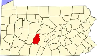
| County | Blair |
| Township | Snyder |
| Area | |
• Total | 1.07 sq mi (2.78 km2) |
| • Land | 1.07 sq mi (2.78 km2) |
| • Water | 0.00 sq mi (0.00 km2) |
| Elevation | 994 ft (303 m) |
| Population | |
• Total | 670 |
| • Density | 624.42/sq mi (241.13/km2) |
| Time zone | UTC-5 (Eastern (EST)) |
| • Summer (DST) | UTC-4 (EDT) |
| ZIP code | 16686[4] |
| Area code | 814 |
| FIPS code | 42-30704 |
| GNIS feature ID | 2630012[2] |
Grazierville is a census-designated place[5] in Snyder Township, Blair County, Pennsylvania, United States. It is located near I-99 and is approximately one mile to the south of the borough of Tyrone. As of the 2010 census, the population was 665 residents.[6]
Demographics
| Census | Pop. | Note | %± |
|---|---|---|---|
| 2020 | 670 | — | |
| U.S. Decennial Census[7] | |||
Education
The school district is the Tyrone Area School District.[8]
References
- ^ "ArcGIS REST Services Directory". United States Census Bureau. Retrieved October 12, 2022.
- ^ a b U.S. Geological Survey Geographic Names Information System: Grazierville, Pennsylvania
- ^ "Census Population API". United States Census Bureau. Retrieved October 12, 2022.
- ^ "Grazierville PA ZIP Code". zipdatamaps.com. 2023. Retrieved June 27, 2023.
- ^ "2010 U.S. Census website". United States Census Bureau. Retrieved February 10, 2013.
- ^ "U.S. Census website". United States Census Bureau. Retrieved May 14, 2011.
- ^ "Census of Population and Housing". Census.gov. Retrieved June 4, 2016.
- ^ "2020 CENSUS - SCHOOL DISTRICT REFERENCE MAP: Blair County, PA" (PDF). U.S. Census Bureau. Retrieved December 22, 2024. - Text list
External links