Chantelle, Allier
Chantelle | |
|---|---|
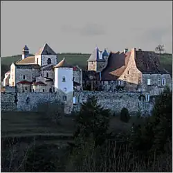 The abbey in Chantelle | |
.svg.png) Coat of arms | |
Location of Chantelle | |
 Chantelle  Chantelle | |
| Coordinates: 46°14′20″N 3°09′14″E / 46.2389°N 3.1539°E | |
| Country | France |
| Region | Auvergne-Rhône-Alpes |
| Department | Allier |
| Arrondissement | Vichy |
| Canton | Gannat |
| Intercommunality | Saint-Pourçain Sioule Limagne |
| Government | |
| • Mayor (2020–2026) | André Bidaud[1] |
Area 1 | 10.96 km2 (4.23 sq mi) |
| Population (2022)[2] | 1,124 |
| • Density | 100/km2 (270/sq mi) |
| Time zone | UTC+01:00 (CET) |
| • Summer (DST) | UTC+02:00 (CEST) |
| INSEE/Postal code | 03053 /03140 |
| Elevation | 258–349 m (846–1,145 ft) (avg. 324 m or 1,063 ft) |
| 1 French Land Register data, which excludes lakes, ponds, glaciers > 1 km2 (0.386 sq mi or 247 acres) and river estuaries. | |
Chantelle (French pronunciation: [ʃɑ̃tɛl]; Occitan: Chantela) is a commune in the Allier department in central France.
Geography
The village lies on the right bank of the Bouble, which forms most of the commune's northern border.
Population
| Year | Pop. | ±% p.a. |
|---|---|---|
| 1968 | 1,121 | — |
| 1975 | 1,069 | −0.68% |
| 1982 | 1,084 | +0.20% |
| 1990 | 1,043 | −0.48% |
| 1999 | 1,040 | −0.03% |
| 2009 | 1,062 | +0.21% |
| 2014 | 1,063 | +0.02% |
| 2020 | 1,105 | +0.65% |
| Source: INSEE[3] | ||
See also
References
- ^ "Répertoire national des élus: les maires" (in French). data.gouv.fr, Plateforme ouverte des données publiques françaises. 13 September 2022.
- ^ "Populations de référence 2022" (in French). The National Institute of Statistics and Economic Studies. 19 December 2024.
- ^ Population en historique depuis 1968, INSEE
External links
Wikimedia Commons has media related to Chantelle.
- Official Web site (in French)