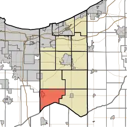
Boone Township, Porter County, Indiana
Boone Township | |
|---|---|
 | |
| Coordinates: 41°18′35″N 87°09′05″W / 41.30972°N 87.15139°W | |
| Country | United States |
| State | Indiana |
| County | Porter |
| Government | |
| • Type | Indiana township |
| Area | |
• Total | 36.23 sq mi (93.85 km2) |
| • Land | 36.2 sq mi (93.76 km2) |
| • Water | 0.03 sq mi (0.09 km2) |
| Elevation | 682 ft (208 m) |
| Population | |
• Total | 6,104 |
| • Density | 170/sq mi (65.7/km2) |
| Time zone | UTC-6 (Central (CST)) |
| • Summer (DST) | UTC-5 (CDT) |
| ZIP code | 46992 |
| Area code | 219 |
| FIPS code | 18-06580[3] |
| GNIS feature ID | 453130 |
Boone Township is one of twelve townships in Porter County, Indiana. As of the 2010 census, its population was 6,160.[4]
History
Boone Township was organized in 1836.[5]
| Census | Pop. | Note | %± |
|---|---|---|---|
| 1890 | 1,357 | — | |
| 1900 | 1,373 | 1.2% | |
| 1910 | 1,403 | 2.2% | |
| 1920 | 1,430 | 1.9% | |
| 1930 | 1,265 | −11.5% | |
| 1940 | 1,585 | 25.3% | |
| 1950 | 1,882 | 18.7% | |
| 1960 | 2,308 | 22.6% | |
| 1970 | 2,715 | 17.6% | |
| 1980 | 4,492 | 65.5% | |
| 1990 | 4,909 | 9.3% | |
| 2000 | 5,884 | 19.9% | |
| 2010 | 6,160 | 4.7% | |
| 2020 | 6,104 | −0.9% | |
| [6] | |||
The Clinton D. Gilson Barn was listed on the National Register of Historic Places in 1984.[7]
Cities and towns
The largest community in the township is Hebron.[8]
Education
Boone Township is served by the Metropolitan School District of Boone Township. Their high school is Hebron High School.
Cemeteries
| Name | Location | Picture | Ref pg[9] | Ref pg[10] |
|---|---|---|---|---|
| Hebron Cemetery | 900 S and US 231, Hebron | 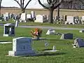
|
pg 47 | back |
| Cornell Cemetery | North of State Route 8, must north of 350W | 
|
pg 53 | back |
References
- ^ "US Board on Geographic Names". United States Geological Survey. October 25, 2007. Retrieved January 31, 2008.
- ^ "Census Bureau profile: Boone Township, Porter County, Indiana". United States Census Bureau. May 2023. Retrieved March 18, 2024.
- ^ "U.S. Census website". United States Census Bureau. Retrieved January 31, 2008.
- ^ "Geographic Identifiers: 2010 Demographic Profile Data (DP-1): Boone township, Porter County, Indiana". U.S. Census Bureau, American Factfinder. Archived from the original on February 10, 2020. Retrieved March 22, 2013.
- ^ History of Porter County, Indiana : a narrative account of its historical progress, its people and its principal interests. Lewis Publishing Company. 1912. p. 129.
- ^ "Township Census Counts: STATS Indiana". www.stats.indiana.edu. Retrieved August 18, 2024.
- ^ "National Register Information System". National Register of Historic Places. National Park Service. July 9, 2010.
- ^ Porter County, Indiana Sesquicentennial, 150, 1836-1986
- ^ Soil Survey of Porter County, Indiana; USDA, Soil Conservation Service, Purdue University Agricultural Experiment Station, Indiana Department of natural Resources, Soil and Water Conservation Committee; February 1981
- ^ Rand MacNally, Porter County, Indiana, 2001
External links
Municipalities and communities of Porter County, Indiana, United States | ||
|---|---|---|
| Cities | 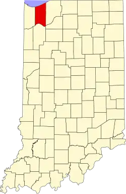 | |
| Towns | ||
| Townships | ||
| CDPs | ||
| Other communities | ||
| Ghost towns | ||
| Footnotes | ‡This populated place also has portions in an adjacent county or counties | |